ecosistemas
ISSN 1697-2473
Open access / CC BY-NC 4.0
© 2026 The authors [ECOSISTEMAS is not responsible for the misuse of copyrighted material] / © 2026 Los autores [ECOSISTEMAS no se hace responsable del uso indebido de material sujeto a derecho de autor]
Ecosistemas 35(3): 3181 [September - December / septiembre - diciembre, 2026]: https://doi.org/10.7818/ECOS.3181
Associate editor / Editor asociada: Pablo Palencia-Mayordomo
RESEARCH ARTICLE / ARTÍCULO DE INVESTIGACIÓN
Geoecological significance and feeding habits of the mountain pocket gopher (Thomomys monticola) on Lassen Peak, an active volcano in the southern Cascade Mountains (California, USA)
Francisco Luis Pérez1,* 
(1) Department of Geography and the Environment, University of Texas, College of Liberal Arts, RLP 3.306, Liberal Arts Building E23rd Street, Austin, Texas 78712-1098, USA.
* Corresponding author / Autor para correspondencia: Francisco Luis Pérez-Sánchez [Halemauu@gmail.com]
|
> Received / Recibido: 18/01/2026 – Accepted / Aceptado: 08/06/2026 |
How to cite / Cómo citar: Pérez, F. L. (2026). Geoecological significance and feeding habits of the mountain pocket gopher (Thomomys monticola) on Lassen Peak, an active volcano in the southern Cascade Mountains (California, USA). Ecosistemas 35(3): 3181. https://doi.org/10.7818/ECOS.3181
|
Geoecological significance and feeding habits of the mountain pocket gopher (Thomomys monticola) on Lassen Peak, an active volcano in the southern Cascade Mountains (California, USA) Abstract: This study focuses on the overall ecosystem characteristics of a pocket gopher (Thomomys monticola) colony inhabiting high-elevation (~2700-3100 m) talus slopes on Lassen Peak, California, an active volcano in the southern Cascade Mountains of northern California. This is the first study assessing the ecological relationships of pocket gophers in an alpine talus-slope environment. I examine the geographic, geomorphic, sedimentological, pedological, and vegetation elements of this system. Talus substrates are very steep (≤32°), extremely unstable, and affected by a diversity of geomorphic processes. Sediments include a large proportion (55-64%) of debris ≤5 cm in diameter. The soil fraction (≤2 mm) consists mainly of fine-grained sandy and silty loams, which facilitate excavation by gophers. Soil organic matter content varies widely (~1-50%) but increases sharply on basal slopes, loosening the soils and allowing substantial water storage (10.8-13.3%) during dry summer months. Thus, gopher activity is concentrated on lower talus areas. Lassen receives significant snowfall (15.2-17.8 m/year) and extensive snowfields persist until late-summer, allowing rodents to dig though the talus snowpack, and providing an ample source of moisture for talus substrates. Substrate instability produces a characteristic root system deformation, with roots oriented upslope from the plant’s base. This causes roots to remain within a shallow soil layer, used by gophers during burrowing. Vegetation presumably utilized by gophers includes 38 vascular plant species (19 herbs, 6 suffrutices, 9 shrubs, and 4 graminoids). Here, I discuss the most important resources provided by these plants. The results obtained underscore (i) the significant role of substrate—both talus sediments and soils—on the digging activities of pocket gophers; (ii) the role of different plant species on their feeding habits; and (iii) the importance of an extensive snowpack during winter burrowing. Keywords: alpine areas; geoecology; geomorphic processes; snowpack; talus; volcanic areas Importancia geoecológica y hábitos alimenticios del topo de montaña (Thomomys monticola) en el pico Lassen, un volcán activo en las Montañas Cascadas del sur (California, USA) Resumen: Este estudio examina las características básicas del ecosistema en una colonia de topos de montaña (Thomomys monticola) que habita conos de derrubios a gran elevación (~2700-3100 m) en el Pico Lassen, California, un volcán activo en las montañas Cascadas del norte de California. Este es el primer estudio sobre las relaciones ecológicas de los topos de montaña en un ambiente de conos de derrubios alpinos. Aquí yo examino los principales aspectos geográficos, geomorfológicos, sedimentológicos, pedológicos, y de vegetación de este sistema. Los sustratos de los conos son muy empinados (≤32°) y extremadamente inestables, ya que son afectados frecuentemente por diversos procesos geomórficos. Los sedimentos incluyen una alta proporción (55-64 %) de fragmentos de ≤5 cm de diámetro. La fracción del suelo (≤2 mm) consiste principalmente en limos arenosos finos, lo que facilita la excavación por los topos. El suelo contiene una cantidad variable (~1-50 %) de materia orgánica, que incrementa marcadamente hacia la base de las pendientes, lo que genera desagregación y alta capacidad (10.8-13.3 %) de almacenamiento de humedad en el suelo durante el período seco de verano. Esto genera una concentración de actividad de los topos en las pendientes bajas. Lassen recibe una gran cantidad de nieve (15.2-17.8 m/año), y extensos depósitos de nieve sobreviven hasta el fin del verano, haciendo posible que los roedores excaven a través del manto de nieve, y también proveen una importante fuente de humedad para los sustratos de los conos de derrubios. La inestabilidad del sustrato produce una deformación característica en los sistemas de raíces, que están orientadas pendiente arriba de la base de las plantas. Esto causa que las raíces permanezcan dentro de la capa superficial del suelo donde los topos excavan. La vegetación aparentemente utilizada por los topos incluye 38 especies vasculares (19 yerbas, 6 sufrútices, 9 arbustos, y 4 graminoideas. En este artículo, analizo los recursos más importantes que aportan estas plantas. Los resultados obtenidos subrayan (i) el papel significativo del sustrato—tanto sedimentos como suelos—en las tareas de excavación de los topos; (ii) la importancia de diferentes especies vegetales para sus hábitos alimenticios; y (iii) el rol crucial de una extensa cobertura de nieve durante las actividades invernales de estos animales. Palabras clave: áreas alpinas; áreas volcánicas; conos de derrubios; geoecología; nieve; procesos geomorfológicos |
Introduction
Mountain pocket gophers (Thomomys monticola) J.A. Allen,1893 (Geomyidae) are small, fossorial rodents, ~25-cm long at adulthood. These animals are well adapted to subterranean existence: they have short stout legs, strong forearms with large claws, and smooth incisors, for digging (Fig. 1a). Their name refers to the fur-lined pouches outside of their mouths used to carry food. In California, their macro-geographic range (Stemp et al., 2021) includes elevations over ~1520 m along the Sierra Nevada and Cascade Mountains, although there is a small, western disjunct population, in the Yolla Bolly (‘snow-covered high peaks’ in Wintun native-American) wilderness area of the Klamath Mountains (Ingles, 1949a; Verner and Boss, 1980; Zeiner et al., 1990). This species also extends slightly northwards into Oregon, to the Rogue River (Fig. 1b).
The main goals of this research are as follows: (a) to assess the meso-geographic distribution of gophers on Lassen Peak, an active volcano in the southern Cascades of northern California; (b) to examine the topographic and geomorphic characteristics of the talus flanks of this volcano, where pocket gophers exhibit sizable populations; (c) to evaluate the basic sedimentological, pedological, and organic properties of soils on the slopes inhabited by gophers; and (d) to describe the plant species gophers use for food and other purposes in this environment.
Burrowing activities of pocket gophers
Pocket gophers are solitary, indefatigable earth-movers, which seldom need to go aboveground to feed. Tunnels provide a safe means of collecting food during the summer. This includes the roots, tubers, bulbs, and fleshy foliage of palatable plants growing down into the burrows. Digging new galleries allows the expansion of food gathering over large areas. Forbs and grasses are preferred food items, although shrubs and woody plants —including trees— may provide additional forage (Verner and Boss,1980; Zeiner et al., 1990). In summer, gophers produce small surface, ≤30-cm-tall, ≤40-cm-diameter, conical mounds, distinctly aligned over their galleries, which grow progressively longer during summer months. In winter, gophers feed on green plant stems, leaves, or roots which the rodents find as they excavate under the snow. In the process, they build extensive networks of tunnels, excavated over the ground surface.
As gophers dig along the snow/soil interface, they produce smooth cylindrical, ~5- to 10-cm-diameter, soil casts by pushing up the friable soil from their burrows. The dry, dead ends of uneaten plants are also compacted into unused burrow sections, often forming ≥1-m-long plugs under the snow (Ingles, 1952; Huntly and Inouye, 1988). An extensive snow cover also facilitates animal dispersal, and colonization of new areas. Thus, pocket gophers are able to travel over rocks, outcrops, and other obstacles that would normally restrict or block movement during snow-free periods (Ingles, 1949b; Hansen and Morris, 1968; Teipner et al., 1983; Mattson, 2004). Soil casts, parallel to the ground surface, settle during snowmelt, providing evidence of animal winter activity (Ingles, 1949b, 1952). Individual tunnels can be extensive (as much as ~37 m long) and are regularly connected with lateral galleries that are used to store food in caches, 8 to 30 cm deep. In such a complex fashion, individual animals may occupy underground home ranges as large as 600 m2 in area (Scheffer, 1908; Wight, 1918; Ingles, 1952; Teipner et al., 1983).
Gophers can transport substantial amounts of sediment to the ground surface, where it is quickly eroded. In the Sierra Nevada, at 2140 m, gophers were able to mobilize an average of ~5.6 kg/mound/day during the summer. This produced ~4.2 metric tons/ha of sediment per month (Ingles, 1952; Teipner et al., 19833). Animals burrow through deep, friable soils, and tend to avoid stones ≥5 cm in diameter, thus excavating through finer material where present (Hansen and Morris, 1968; Steinberg and Heller, 1997). Pocket gophers are common in a variety of environments, including grasslands, prairies, meadows, open coniferous forests, brushlands, and alpine areas.
Feeding habits of pocket gophers
Gophers and other fossorial rodents can have significant impacts on vegetation (Burton and Black, 1978; Reichmann and Smith, 1985; Inouye et al., 1987; Case, 2012; Case et al., 2013). At some sites, gophers eat a wide range of plants, which include many species. Bandoli (1981) observed a strong seasonal variation in feeding behavior: some plants were always important in the gopher diet, while others were used seasonally; these made up the bulk of their diet. In contrast, several plants were available year-round but rarely became preferred foods. Others, apparently highly valued, were sporadically important regardless of availability. Several studies have focused on the preferred diet, or feeding habits, of gophers (Aldous, 1951; Burton, 1977; Burton and Black, 1978; Behrend and Tester, 1988; Jenkins and Bollinger, 1989). This is a reasonable approach; however, it implies that plants are utilized by gophers solely as foodstuff, and not for other reasons. In 1945, Aldous (1945, p. 328), excavated a food cache containing ‘millions of dandelion seeds’ that had been gathered and stored, but never consumed. At the time, he had no explanation for such behavior. Later, Aldous (1951, p. 84) perceptively concluded that a more appropriate term for this activity was the ‘cutting’ rather than ‘feeding’ habit of gophers’. After examining 48 plant species removed from the aboveground vegetation, he concluded: ‘It is difficult to determine just what per cent of the vegetation removed from an area by gophers is actually eaten since some is used for nest building, some is stored and not eaten, and a part is taken into the runway and later pushed to the surface in relatively fresh condition’.
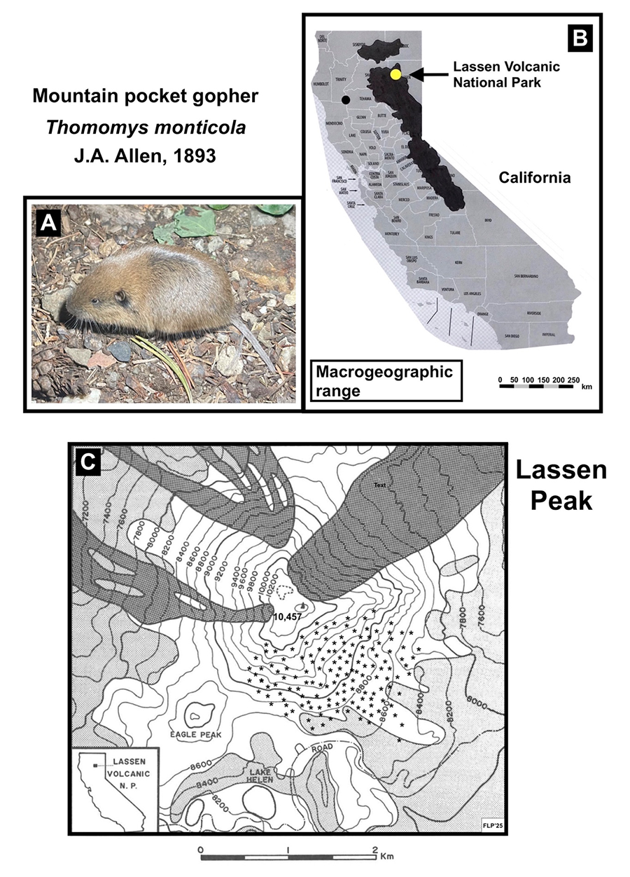
Figure 1. A) Adult Mountain pocket gopher (Thomomys monticola) J.A. Allen, 1893. Image licensed under Creative Commons, CC by-nc 4.0. Rights holder: wyattherp, identifier: https://inatu.../photos/316515692. See gbif.org/occurrence/5154560433. B) Macro-geographical distribution of the mountain pocket gopher (Thomomys monticola) in California; location of Lassen Volcanic National Park is shown. Scale in km. Data adapted from Zeiner et al., 1990. County map from California counties: map1.gif, image in Public Domain, author Thadius856 (see licence). C) Inset: Location of Lassen Volcanic National Park. Lassen Peak; dark shading shows mountain sections recently affected by volcanic activity; details adapted from Williams (1932). Light shading indicates approximate extent of subalpine forests; small asterisks indicate areas of pocket gopher habitat. Base maps: Lassen Peak, Manzanita Lake, and Mt. Harkness (1956), and Prospect Peak (1957). U.S. Geological Survey, 15’ quadrangles, 1:62,500. Elevations in feet, contour interval: 200 feet, scale in km.
.svg?uselang=en#Licensing)
Figura 1. A) Individuo adulto de topo de montaña (Thomomys monticola) J.A. Allen, 1893. Imagen usada con licencia de Creative Commons, CC by-nc 4.0. Derechos de autor: wyattherp, identificación: https://inatu.../photos/316515692. Véase gbif.org/occurrence/5154560433. B) Distribución macro-geográfica del topo de montaña (Thomomys monticola) en California; ubicación del Parque Nacional Lassen incluida. Escala en km. Datos adaptados de Zeiner et al., 1990. Mapa de condados de California: cmap1.gif, image in Public Domain, author Thadius856 (ver licencia). C) Recuadro: ubicación del Parque Nacional Lassen. Pico Lassen; sombreado oscuro muestra secciones recientemente afectadas por actividad volcánica; detalles adaptados de Williams (1932). Sombreado claro indica extensión aproximada de los bosques subalpinos; pequeños asteriscos indican áreas de hábitat del topo de montaña. Mapas base: Lassen Peak, Manzanita Lake, and Mt. Harkness (1956), y Prospect Peak (1957). U.S. Geological Survey, 15’ quadrangles, 1:62,500. Elevación en pies, intervalo de cotas: 200 pies, escala en km.
Influence of pocket gophers on the composition of vegetation
Mound building by gophers also has important effects on the vegetation. Numerous studies have shown that gopher burrowing affects plant community structure and composition (Ellison and Aldous, 1952; Laycock and Richardson, 1975; Hobbs and Mooney, 1985), and may even increase species diversity (Tilman, 1983; Martinsen et al., 1990; Sherrod et al., 2005). Bare mounds provide an open surface for plant establishment and reduce competition for surviving plants (Hobbs and Mooney, 1985). Exposed soils on mounds also exhibit lower bulk density than surrounding undisturbed soils; this may help with the establishment of many plant species, including trees near treeline (Sherrod and Seastedt, 2001; Butler and Butler, 2009). Due to dry soil conditions and exposure to herbivores, seedling mortality on mounds tends to be very high, but surviving individuals are often larger, and produce more seeds than comparable plants on the adjacent soil around mounds (Reichman and Seabloom, 2002; Simkin and Michener, 2004).
Forbs are particularly resilient to disturbance by pocket gophers, and benefit from their mounding activities (Aldous, 1951; Laycock and Richardson, 1975; Foster and Stubbendieck, 1980). Forbs are more abundant in gopher-disturbed areas due to their greater ability to recover from burial (Hobbs and Mooney, 1985; Williams et al., 1986). This confers them a competitive advantage over other growth forms, such as graminoids (Sherrod et al., 2005).
In alpine soils on Niwot Ridge, Colorado, seedling emergence and survival were lower on new gopher mounds than in adjacent undisturbed soils. However, after 5 years, mounds showed greater seedling density and survival, although tree seedlings were absent (Forbis et al., 1994). In the same alpine environment, Schütz (2005) found that gopher activities did not damage juvenile conifers. In contrast, in a longleaf pine-wiregrass savanna in Georgia, tree seedlings showed slightly (albeit not significantly) greater survival on mounds than in the surrounding soil matrix (Simkin and Michener, 2004).
Previous research methods and areas of study
Various methods have been used to assess the vegetation consumed by pocket gophers: (a) identifying all plant species present in study plots, with the assumption that gophers would use most—or at least some—of them (Burton, 1977; Burton and Black,1978; Gottfried and Patton, 1984; Connior et al., 2010); (b) examining rodents’ dry fecal pellets (Ingles, 1949b, 1951, 1952; Behrend and Tester, 1988; Connior, 2011); (c) ‘destructive sampling’—often slaughtering hundreds of animals—to examine their stomach contents (Myers and Vaughan, 1964; Vaughan, 1967; Burton, 1977; Burton and Black, 1978; Tryon and Cunningham, 1968; Luce et al., 1980; Gottfried and Patton, 1984; Behrend and Tester, 1988); (d) excavating and analyzing food caches and tunnel plugs (Aldous, 1945, 1951; Ingles, 1952; Vaughan, 1967; Bandoli, 1981; Mattson, 2004; Stinson, 2013); (e) sampling plant materials growing on gopher mounds inside exclosures designed to exclude cattle and other grazers (Aldous, 1951); and (f) monitoring plant use by direct observation of feeding, and examination of discarded plant parts (Burton, 1977; Burton and Black,1978; Pérez, 2012; Stinson, 2013).
Most gopher research in North America has taken place in lowland prairies, although several studies have focused on high-mountain environments (Aldous, 1945, 1951; Ingles, 1949a, 1949b, 1952; Hansen and Morris, 1968; Tryon and Cunningham, 1968), and some volcanic areas and soils of Oregon (Burton, 1977; Burton and Black,1978; Case et al., 2013) or Washington state (Andersen, 1982; Andersen and MacMahon, 1985; Jenkins and Bollinger, 1989; Stinson, 2013). Apparently, no reports have specifically focused on alpine taluses as a habitat for gophers. This is the first study focused on ecological relationships of pocket gophers in an alpine talus-slope environment. Most published studies have addressed specific biological or pedological elements, but few authors have considered the broader ecological and environmental relationships of gophers (Teipner et al., 1983; Busch et al., 2000). Margalef (1974, p. 882) clearly identified the key elements of interest for ecologists: ‘El verdadero nivel de atención de la Ecología es el ecosistema entero’; following Odum’s fundamental ecosystem concept (Odum, 1971, p. 8): ‘Living organisms and their nonliving (abiotic) environment are inseparably interrelated and interact upon each other’. In this study, I focus on the most relevant connections of mountain pocket gophers with the broader components of their physical, geomorphic, and biological environments.
Methods
Study area
Lassen Peak is an isolated, 3187-m-high, andesitic dome volcano at the southern end of the Cascade Mountains (40° 29’ N, 121° 30’ W) and is a significant part of Lassen Volcanic National Park (LVNP). Lassen formed ~28 300 ± 2700 BP (Muffler and Clynne, 2015) and erupted again on 30 May 1914, with ~400 explosive episodes recorded through 1921 (Harris and Tuttle, 1983). These latter eruptions caused a massive lahar and three smaller debris-flows that devastated its northern (NE to NW) slopes (Williams, 1932). Only the eastern to southwestern (E to SW) flanks were left undisturbed (Fig. 1c). Any rodent populations present at the time of these eruptions were likely to have been decimated or extinguished (Andersen, 1982, Andersen and MacMahon, 1985). Lassen’s slopes are covered by massive talus deposits, produced by subsequent dome disintegration and weathering of dacite cliffs (Williams, 1932; Pérez, 1989) (Figs. 2a, 2e, 2f, 2g).
LVNP has a Mediterranean climate, with hot, dry summers and cool winters. Precipitation averages ~1750 mm at ~2450 m elevation. Due to strong seasonality, snowfall accounts for ~95 % of the annual total (Elford, 1974; Pérez, 1988). Annual snowfall at Lake Helen (2515 m), below Lassen’s south flank, averages 15.2-17.8 m (maximum of ≥25.0 m/yr), making this peak the snowiest place in California (Cascade Snowfall and Snowdepth, 2006) (Figs. 2c, 2d). Subalpine coniferous forests of mountain hemlock (Tsuga mertensiana) and white-bark pine (Pinus albicaulis) reach timberline along an irregular boundary, at 2500-2600 m elevation. Beyond the forest line, small isolated tree islands of both species extend up to ~3060 m (Pérez, 1990) (Fig. 1c).
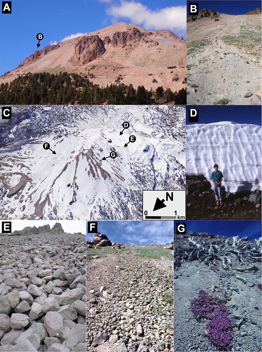
Figure 2. Lassen photomosaic. A) South flank of Lassen Peak above Lake Helen. The talus studied lies below the tall dacite outcrops; the largest cliff at the center is Vulcan’s Eye. The coniferous treeline below lies here at ~2550-2670 m; white letters in circles indicate approximate locations of the other photos on this figure. Photo: Las-14-126, Aug. 16, 2014. B) Broad debris-flow track on Lassen’s upper WSW slope; this debris-flow transported much fine debris sediment onto basal slopes; Lupinus obtusilobus covers much of the midslope; ~2765 m elevation. Photo: Las-90-643, July 27, 1990. C) Winter oblique satellite view of Lassen Peak, from the NNW; North and approximate scale (km) in foreground are shown on the lower right. Image used with kind permission from Google Maps/Google Earth, Landsat/ Copernicus, following Universal Terms of Service. Imagery date: 12/30/1985. Photo centered at 40°28’08.81” N, 121°30’40.50” W, elevation 2490 m, camera elevation 7306 m. D) Snowpack on basal S talus; snow thickness is ~3.3 m. Photo: Las-93-389, July 27, 1993. E) Block talus on the upper-mid SW flank (not studied); largest block (with dot) is ~42-cm-long. Slope angle: ~36°, ~2900 m elevation. Photo: Las-85-222, July 12, 1985. F) Fine-debris talus on the upper SE flank; area of gopher activity. Extensive cover of Lupinus obtusilobus seen in upper photo section. Slope angle: ~33°, ~2835 m elevation. Photo: Las-83-555, Sep. 19, 1983. G) Fine-debris talus on upper W flank, near Lassen’s crater. The dead trunks of white-bark pine were presumably killed by the 1914-1915 eruptions. Ground cover is a ~185-cm-long mat of Penstemon davidsonii. Photo: Cal-82-470, July, 31 1982. Slope angle: ~36°, ~2990 m elevation.
Figura 2. Fotomosaico de Lassen. A) Flanco S del Pico Lassen, por arriba de Lake Helen. El talo estudiado está bajo los altos afloramientos dacíticos; el mayor acantilado, al centro, es Vulcan’s Eye. El límite del bosque de coníferas está a ~2550-2670 m; las letras blancas en círculos indican la posición aproximada de las otras fotos en esta figura. Foto: Las-14-126, 16 Agosto 2014. B) Amplio flujo de barro en el flanco OSO de Lassen; este flujo transportó cuantioso material fino a la base del talo. Extensa cobertura de Lupinus obtusilobus aparece en la pendiente media; ~2765 m de elevación. Foto: Las-90-643, 27 Julio, 1990. C) Vista oblícua de satélite del Pico Lassen en invierno, desde el NNO; el Norte y la escala aproximada (km) al frente aparecen en la esquina inferior derecha. Imagen usada con permiso de Google Maps/Google Earth, Landsat/ Copernicus, de acuerdo a Universal Terms of Service. Fecha de la imagen: 12/30/1985. Foto centrada a 40°28’08.81” N, 121°30’40.50” W, 2490 m elevación, elevación de cámara: 7306 m. D) Manto de nieve en la base del talo S; la nieve tiene ~3.3-m espesor. Foto: Las-93-389, 27 Julio, 1993. E) Talo de bloques en el flanco medio SO (no estudiado); el bloque mayor (con un punto) tiene ~42 cm de longitud. Pendiente: ~36°, ~2900 m de elevación. Foto: Las-85-222, 12 Julio, 1985. F) Talo de partículas finas en el flanco SE superior, en área de actividad de topos. Una Extensa cobertura de Lupinus obtusilobus aparece en la sección superior. Pendiente: ~33°, ~2835 m de elevación. Foto: Las-83-555, 19 Sept., 1983. G) Talo de partículas finas en el flanco superior oeste, cerca del crater de Lassen. Los troncos muertos de pino de corteza blanca fueron presumiblemente arrasados por las erupciones volcánicas de 1914-1915. La planta al frente es un Penstemon davidsonii de ~185 cm de longitud. Foto: Cal-82-470, 31 Julio 1982. Pendiente: ~36°, ~2990 m de elevación.
The higher peaks at LVNP harbor several rodents, including mountain gophers (Thomomys monticola), yellow-pine chipmunks (Eutamias amoenus), golden-mantled ground squirrels (Spermophilus lateralis), pikas (Ochotona princeps), and bushy-tailed woodrats (Neotoma cinerea). These animals inhabit the talus slopes flanking these mountains (Verner and Boss, 1980; Pérez, 2012). The first two species are particularly common on Lassen Peak.
Field and laboratory methods
Fieldwork was conducted over the summers of 1981 to 1993. Data was originally collected for research focused on geomorphology, soils, and plant distribution on Lassen volcano. Data specifically relevant to the distribution and ecology of pocket gophers were selected for this publication and are reported. Pocket gopher populations were observed above timberline, both on the S and SE slopes. No signs of rodents were seen on the SW flank, which are largely covered by massive blocks, leaving very few areas of fine-debris suitable for gophers (Fig. 2e). Topographic profiles and slope inclination were measured along two flanks using a compass, hand-held clinometer, and meter tape stretched taut between stations spaced 10 m apart. Elevation was ascertained with ThommenTM altimeter (estimated error: ±10 m) (Fig. 3a). Different methods were used to describe the substrate inhabited by pocket gophers. Sediment granulometry was determined on plots at mid-upper and mid-lower talus areas with a large, 4000-cc (~8+ kg) sampler (cf. Steinberg and Heller, 1997). Samples were air dried for 6 weeks and hand sieved through a 17-mesh (0.002-100 mm) series (Pérez, 1989) (Fig. 3b). Additionally, the soil (≤2-mm) fraction of talus substrates was assessed in gravelly-sand areas of the S and SE flanks at 30 random locations by gently pressing a 125-cc iron cylinder into the upper 10 cm of topsoil. Particle-size distribution was evaluated after air- and oven-drying samples at 105°C for 48 hrs, then hand-sieving through a 12-mesh (0.036-2 mm) sequence (Pérez, 1998a). Fine-grain (≤0.036 mm) content was calculated with BouyoucosTM hydrometers (ASTM-152h) using sodium hexametaphosphate as a dispersing agent (Fig. 3c). The organic-matter component of talus soils was measured, between 2560 and 3060 m elevation for 35 samples of bare soil, as well as for 33 samples collected beneath small islands of white-bark pine. Soil organic matter (SOM) was determined by overnight loss of weight on ignition (LOI) at 375°C, as this temperature does not affect other soil properties (Ball, 1964; Pérez, 1990) (Fig. 2d).
On 14 August 1991, 5 fresh summer mounds and 5 surviving winter casts were sampled along the basal SE flank (~12° slope). Unconfined soil compressive strength was measured perpendicularly to the ground surface with a SoiltestTM CL-700 handheld pocket penetrometer fit with a base adaptor sensitive to low compressibility (Zimbone et al.,1996; Butler and Butler, 2009). Ten measurements were obtained on each type of gopher feature, and 20 measurements were taken on adjacent controls (undisturbed exposed-soil patches within ~120 cm).
Percentage plant cover was estimated along seven ~30.5-m-long, point-intercept transects (PITs) (Mueller-Dombois and Ellenberg, 2003) parallel to slope contours, evenly spaced every ~100 m along talus longitudinal profiles (Fig. 3a). Three PITs were located on the S flank and four on the SE flank. Each comprised 100 measurement points. All vascular plant species present were identified. Voucher specimens were compared to collections at the Jepson Herbarium (University of California-Berkeley) and Plant Resources Center (University of Texas-Austin). Identifications were also aided by two web-based resources, ‘The University and Jepson Herbaria’ (ucjeps.berkeley.edu) and ‘Calflora Taxon Report’ (Calflora.org/app/taxon). Nomenclature follows Munz and Keck (1970) and Munz et al. (2003). Recognized plant families are from the APG (Angiosperm Phylogeny Group) (Stevens, 2017). Species’ elevational ranges and relative frequencies (Hickman (1993) were determined from extensive talus surveys. Frequencies were defined as a, abundant: numerous and widespread (present on all talus sites); c, common: several individuals found on many talus sites; u, uncommon: a few individuals present on some talus sites; r, rare: very few individuals limited to one site. To identify the species likely utilized by pocket gophers, I consulted all available records and references that seemed relevant. I assigned each of these species to one of two groups: (1) species for which there was direct evidence of consumption on Lassen Peak, and where these (or closely related) taxa were reported as utilized by pocket gophers elsewhere (cf. Stinson, 2013); and (2) species possibly utilized by rodents, based on several criteria: plant morphology, including above- and below-ground traits of species, woodiness, leaf texture, fruit and seed characteristics, type of inflorescence, bulb presence, water content, and species abundance in the field. The root systems of 30 plant species were excavated and examined on the talus slopes. In total, 310 individuals were carefully excavated by hand or using a small trowel (Young and León, 1990). Root-system diagrams were drawn from photos, sketches, and field observations (four such drawings are included in this report).
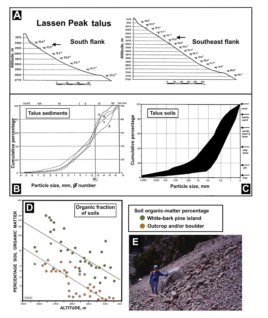
Figure 3. A. Longitudinal slope profiles for Lassen’s south (S) and southeast (SE) flanks; graphic shows no vertical exaggeration. Steeper sections at the top indicate volcanic dacite cliffwalls. Slope values are averages of 4-12 measurements within each elevational section. Elevations and scale are in meters. Horizontal arrows show approximate maximum elevation where gopher features were found. B. Cumulative particle-size distribution of talus sediments. Key: 1: upper S talus; 2: basal S talus; 3: upper SE talus; 4: basal SE talus. RL: ~5 cm rock limit. Scale in Phi (ø) (negative logarithm scale, American Geological Institute, 1976) and mm. C. Shading shows graphic envelope for cumulative particle-size distribution of talus soils (≤2-mm diameter) for 30 samples at 2720-3055 m on Lassen Peak. Approximate equivalent textural classes for a USDA texture triangle appear to the right. D. Soil organic fraction (SOM) for 35 surface bare soils (brown circles) and 33 soils under white-bark pines (green circles) on Lassen Peak, between 2560 and 3060 m. Logarithmic regressions: bare soils, Log10Y = 6.033 – 0.00200X, r = -0.633 (p< 0.001); under pines, Log10Y = 6.499 – 0.00197X, r = -0.677 (p< 0.001). E. Massive accumulation of talus debris upslope of a ~155-cm-tall boulder embedded in Lassen’s S flank; slope angle: ~34°. The base of Vulcan’s Eye appears in background; photo: Las-93-410, July 26, 1993.
Figura 3. A. Perfiles topográficos de los flancos sur (S) y sureste (SE) de Lassen; el gráfico no muestra exageración vertical. Secciones empinadas al tope muestran las paredes volcánicas de dacita, valores angulares son promedios de 4-12 mediciones en cada sección de elevación. Elevaciones y escalas son en metros; flechas horizontales muestran la elevación máxima aproximada de las áreas con indicios de topos. B. Distribución cumulativa de partículas en sedimentos de los talos. Clave: 1: talo S superior; 2: talo S inferior; 3: talo SE superior; 4: talo SE inferior. RL: límite de rocas ~5 cm. Escala en phi (ø) (escala logarítmica negativa, American Geological Institute, 1976) y mm. C. El sombreado indica el área de distribución cumulativa de partículas en los suelos de talos (≤2-mm diámetro) a 2720-3055 m en el Pico Lassen. A la derecha aparecen las clases de textura aproximadamente equivalentes en un triángulo USDA de texturas. D. Fracción orgánica (SOM) en 35 suelos desnudos superficiales (círculos marrones) y 33 suelos bajo pinos de corteza blanca (círculos verdes) en Lassen, entre 2560 y 3060 m. Regresiones logarítmicas: (suelos desnudos), Log10Y = 6.033 – 0.00200X, r = -0.633 (p< 0.001); bajo pinos: Log10Y = 6.499 – 0.00197X, r = -0.677 (p< 0.001). E. Acumulación masiva de sedimentos de talo por arriba de una peña—~155-cm-altura—firmemente incrustada en el flanco S de Lassen; ángulo: ~34°. La base de Vulcan’s Eye aparece al fondo; foto: Photo: Las-93-410, 26 Julio, 1993.
Results and Discussion
Topography and geomorphology on Lassen Peak
The area inhabited by T. monticola extended from upper talus slopes at ~2950-3000 m (~33° inclination; Fig. 3a, arrows) to the mountain base and beyond, on gentle (8-10°) slopes, along the discontinuous forest line at ~2600 m elevation (Fig. 1c). Some gopher species, like T. mazama in Washington, reportedly avoid slopes steeper than ~22° (Nelson and Carlson, 2024), but others —including T. bottae in southern California— colonize slopes of up to 30° (Seabloom et al., 2000). Because the costs of excavation are considerably greater than the costs of working against gravity (Vleck, 1979, 1981), movement of subterranean animals becomes largely unaffected by slope angle, thus gopher tunnels may be oriented independent of gradient (Reichman and Aitchison, 1981; Seabloom et al., 2000). Judging by the distribution of winter casts, much tunneling on the upper talus probably occurs during winter, through the thick snowpack (Ingles, 1949b, 1952; Hansen and Morris, 1968) (Fig. 4a). More significantly, talus substrates on Lassen are extremely unstable, leading to frequent rockfalls, snow avalanches, snow-gliding, dry-debris slides, small debris flows (Fig. 2b), and talus creep (Fig. 3e) (Pérez, 1988, 1989, 1998b, 2012). Gophers appear to cope with this dynamic, changing substrate.
Sediments and soils on Lassen Peak
Sediments on both talus slopes and sections showed similar particle-size distributions (Fig. 3b): 57-64% of the debris in the SE flank, and 55-60% of the debris in the S flank, were smaller than ~5 cm in diameter (rock limit: RL; Fig. 3b). These percentages are very similar to those found by Steinberg and Heller (1997, Fig. 2) in prairies of western Washington, where T. bottae was present. Surprisingly, the soil fraction (≤2-mm) of these sediments was fine enough on Lassen for gophers to tunnel through them. In contrast, Stinson (2013, p. 23) found that the soil textures in Washington prairies used by T. bottae consisted of loamy sand, sandy loam, loam, and silty loams. The corresponding values for Lassen’s soils were ~11% sand, ~19% loamy sand, ~27% sandy loam and loam, ~26% silty loam, and ~15% silt, with only 2.3% clay (Fig. 3c, right legend; Pérez, 1998a). Interestingly, at Chaos Crags, a nearby volcano where pocket gophers are absent, has considerably coarser substrates: ~11-17% are ≤5 cm in diameter (RL), with greater sand content (~96%) and only 3.3% silt and 0.9% clay. These differences likely reflect the significantly younger age (thus coarser texture) of the talus at Chaos Crags, formed by debris avalanches in 1675 A.D. (Pérez, 1998b).
Soil organic matter (SOM) on Lassen Peak
In contrast to the sediments and fine soil fractions, SOM was quite variable, with some sites characterized by 50% organic matter and others, barely more than 1-2%. Two clear trends were apparent: (1) SOM was significantly greater in areas near vegetation; and, (2) SOM sharply decreased at higher elevations (Fig. 3d). This elevational gradient reflects the fact that tree size, and organic matter production decline with elevation in many mountainous areas (cf. Pérez, 1987; Townsend and Vitousek, 1995; Sah and Brumme, 2003; Lemenih and Itanna, 2004; Sheikh et al., 2009). These trends in SOM result in greater soil moisture in the mid- and lower-talus sections, particularly during the drier summer period (10.8-13.3% at 10-15-cm-depth) (Pérez, 1998a). Greater SOM content would also loosen the soil and facilitate gopher burrowing (Nelson and Carlson, 2024). Extensive snowfields that persist in late summer provide an important source of soil moisture. Comparable gopher studies (Miller, 1948, 1957; Stinson, 2013) found the optimal soil-moisture range for summer digging of Thomomys through a sandy loam in central California was ~9-18%, while moisture content in Colorado’s highlands fluctuated largely between 8 and 19% (Miller and Bond, 1960; Teipner et al., 1983). Thus, the range measured at Lassen would appear to provide favorable digging conditions for pocket gophers.
Burrowing features of pocket gophers
I observed various signs of gopher activity, although most were ephemeral. Pocket gopher activity was abundant on gravelly-sand talus areas of the SE and S flanks, where fine-soil winter plugs and small summer mounds were often seen between the mid-slope and basal talus (Figs. 4a, c, d). An extensive snowpack, which usually persists into summer, encouraged the construction of abundant gopher castings, easily found during summer fieldwork. Pocket gophers cause considerable bioturbation to talus substrates on Lassen Peak (Butler, 1995; Steinberg and Heller, 1997; Meysman et al., 2006; Butler and Butler, 2009). As animals tunnel through soil, they displace larger clasts and compact finer particles. This selective process concentrates finer soil along their tunnels and casts (Hansen and Morris, 1968; Reichman and Seabloom, 2002), but this backfilled soil is less compact than the original substrate (Teipner et al., 1983; Nelson and Carlson, 2024), and it erodes easily (Fig. 4d). Soil compressive strength for both casts and mounds averaged 0 g/cm2, but that of undisturbed soil near mounds and casts was 1.01 ± 0.33 and 0.97 ± 0.27 g/cm2, respectively. Two-sample Kolmogorov-Smirnov tests indicated the differences among sampling positions were highly significant (p<0.001).
Plants utilized by pocket gophers on Lassen Peak
Total plant cover on Lassen’s talus differed significantly on the two mountain flanks. Cover was much higher on the SE flank, where it ranged from 25.8% to 44.6% (mean of 32.7%, n = 4), whereas cover along the S flank varied from 2.5% to 14.1% (mean of 7.3%, n = 3) (Pérez, 2012). These differences in plant cover were associated with differences in life form composition between the two flanks: the SE flank was dominated by an herb, Lupinus obtusilobus (Figs. 2f, 4c), which attained a mean cover of 22.9%, but it had low cover of shrubs (mean of 1.2%). In contrast, the S flank had only 2.5% average cover of Lupinus, and 2.9% cover of shrubs and suffrutices, mainly Phyllodoce breweri and Penstemon davidsonii (Fig. 2g). Plants showed a characteristic deformation, as most individual’s roots were found upslope from their shoot base (Young and León, 1990; Pérez, 2012). This asymmetrical root distribution is caused by continuous substrate instability and the ensuing talus creep. As mobile debris gradually buries stems and roots, plants are progressively pushed downslope (Figs. 4b, 4e-4h). Only a shallow, ~10- to 30-cm-thick, surficial layer is affected by these geomorphic processes; thus the deformed root systems of most plants remain within the soil depth largely used by gophers for burrowing.
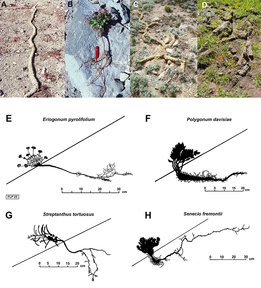
Figure 4. Examples of areas and plants associated with pocket-gopher activity. A) Fine-soil winter castings built under the snow cover—recently disappeared, after late-summer thawing—on a gravelly-sand area with abundant, small Eriogonum pyrolifolium rosettes; mid-slope S talus, ~2915 m elevation, ~29° slope angle. Photo: Cal-83-565, Sep. 20, 1983. B) Freshly excavated, ~66-cm-long individual of Eriogonum pyrolifolium, mid-slope S. Roots: ~43 cm long; foliage surface rosette: ~23 cm tall; pocket knife: 8.5 cm. Photo: Cal-90-506, July, 24, 1990. C) Winter castings in an area with dense Lupinus obtusilobus growth, basal SE talus, ~2755 m elevation, ~31° slope angle. Diameter of individual castings: ~7-10 cm; photo shows an area ~150 cm wide. Note persistent avoidance behavior of gophers, burrowing around larger stones. Photo: Las-86-58, August 27, 1986. D) Disintegrating winter castings near Crumbaugh Lake, 2210 m, LVNP; lens: 5.5 cm diameter. Photo: Las-90-734, July 30, 1990. Note the darker color and finer texture of the soil castings in the basal slopes (C, D). E-H) Plant architecture and root-system diagrams created from photos and field sketches; inclined lines represent fine-grained talus surfaces. Scales are in cm (note the differing scale for H).
Figura 4. Ejemplos de áreas y plantas asociadas con actividad de topos. A) Moldes de suelo fino construidos bajo la nieve—recientemente derretida, tras un deshielo tardío—en áreas de partículas finas, con abundantes pequeñas rosetas de Eriogonum pyrolifolium; pendiente media, talo S, ~2915 m de elevación, pendiente: ~29°. Foto: Cal-83-565, 20 Sept. 1983. B) Individuo recientemente excavado, ~66 cm de longitud de Eriogonum pyrolifolium, pendiente media, S. Raices: ~43 cm de longitud; follaje de roseta superficial: ~23 cm de altura; cuchillo: 8.5 cm. Foto: Cal-90-506, 24 Julio, 1990. C) Moldes de invierno en área con denso crecimiento de Lupinus obtusilobus, en la base del talo SE, ~2755 m de elevación, pendiente: ~31°. Diámetro de moldes individuales: ~7-10 cm; la foto muestra un área ~150 cm de anchura. Nótese el persistente hábito de los topos de evitar piedras grandes, excavando alrededor de ellas. Foto: Las-86-58, 27 Agosto, 1986. D) Moldes de invierno desintegrandose cerca del Lago Crumbaugh, 2210 m, LVNP; lente: 5.5 cm de diámetro. Foto: Las-90-734, 30 Julio, 1990. Nótese el color más oscuro y la textura más fina de los moldes en las pendientes basales (C, D). E-H) Diagrámas de la arquitectura de sistemas de raíces de plantas, compilados de fotos y bocetos de campo; líneas inclinadas muestran la superficie del talo en áreas de partículas finas. Las escalas son en cm (nótese la escala diferente para H).
All of the plants observed on Lassen Peak are characteristic of high-elevation ecosystems in California. These included 8 trees, 12 shrubs, 13 suffrutices (plants with a woody caudex or base, Hickman, 1993), 39 herbs, 5 graminoids (grasses and sedges), and 2 pterophytes (a total of 79 species; Pérez, 2012). The 38 vascular plant species presumably used by pocket gophers included a diversity of life forms, including 19 herbs, 6 suffrutices, 9 shrubs, and 4 graminoids (Fig. 5, Table 1). Their broader elevational distributions (~610 to ~4300 m) encompass that of the talus (~2700 to 3100 m) (Fig. 3a). In previous studies, several species were prominent items in their diets, although a wider variety of species was consumed (Myers and Vaughan, 1964; Bandoli, 1981; Behrend and Tester, 1988; Connior, 2011).
Gophers on Lassen most likely feed on a subset of species because they are more common on the talus (e.g., Lupinus obtusilobus), are more palatable, have greater nutritional value, or provide more water (e.g., Polygonum davisiae). Several species of Brassicaceae (Streptanthus tortuosus, Physaria occidentalis, Draba aureola, Arabis platysperma) supply nourishing silique pods. Other species (e.g. Arctostaphylos nevadensis, Chrysolepis sempervirens, Sambucus racemosa, Cryptantha affinis) offer valuable resources in fleshy fruits (e.g., drupes), burs, or nutlets. Still others provide succulent roots, caudices, or basal rosettes (Eriogonum pyrolifolium, Penstemon davidsonii, Penstemon newberryi, Senecio fremontii, Erigeron glacialis, Monardella odoratissima), or valuable pods and seeds (Phacelia hastata, Cycladenia humilis), or highly-prized bulbs (Allium campanulatum) (Stinson, 2013).
Mountain gophers are adaptable in their feeding habits, and their preferences are generally responsive to local and/or seasonal availability of foods (Burton, 1977; Burton and Black, 1978; Teipner et al., 1983), thus the range of plants used by gophers on Lassen probably varies in space and time. However, if driven by scarcity or necessity, gophers will try to eat any available plants (Aldous, 1945, 1951; Ingles, 1952; Stinson, 2013). The wide variety of potentially accessible plants on Lassen may support the continuous survival of this montane gopher population.
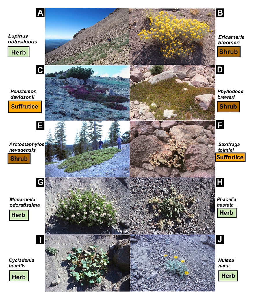
Figure 5. Examples of plant species utilized by pocket gophers; plant life forms are indicated.
Figura 5. Ejemplos de especies de plantas utilizadas por los topos; las especies y su forma biológica son indicadas.
Table 1. List of plant species presumably A) and possibly B) utilized by pocket gophers (Thomomys monticola) on Lassen Peak’s talus slopes. Plant species are arranged by relative abundance (frequency of occurrence) and by life form. Relative abundance codes follow Hickman (1993): a, abundant; c, common; u, uncommon, and r, rare.
Tabla 1. Lista de especies de plantas presumiblemente A) y posiblemente B) utilizadas por los topos de montaña (Thomomys monticola) en las pendientes del Pico Lassen. Las especies están organizadas por su abundancia relativa (frecuencia de ocurrencia) y por su forma biológica. Los códigos de abundancia relativa siguen a Hickman (1993): a, abundante; c, común; u, poco común, y r, rara.
A) Presumably used./ A) Especies presumiblemente utilizadas.
|
N |
Plant species |
Family |
Life form |
Elevational range, m |
Relative abundance |
Plant parts apparently utilized |
|
1 |
Lupinus obtusilobus A. Heller |
Fabaceae |
herb |
2500-3500 |
a |
seeds, 4-cm pods, fleshy roots, stemsb, c, e, f, r, t, u |
|
2 |
Phacelia hastata Lehm. Var. compacta (Brand) Cronquist |
Boraginaceae |
herb |
1500-4000 |
a |
leaves, roots, ovoid 3-mm capsules, 2-mm seedse, f, k |
|
3 |
Eriogonum pyrolifolium Hook. |
Polygonaceae |
suffrutice |
1700-3200 |
a |
succulent leaves, 4-cm rosette, inflorescenceb |
|
4 |
Penstemon davidsonii Greene var. davidsonii |
Plantaginaceae |
suffrutice |
2000-3600 |
a |
succulent, fleshy roots, leaves i, j, u |
|
5 |
Polygonum davisiae A. Gray |
Polygonaceae |
suffrutice |
1500-2800 |
a |
fleshy root, water sourceb, e, f, k, t |
|
6 |
Carex helleri Mack. |
Cyperaceae |
sedge |
2400-4100 |
a |
inflorescence, 4-mm fruitb, m |
|
7 |
Senecio fremontii Torr. & A. Gray
|
Asteraceae |
herb |
2600-3600 |
a - c |
succulent leaves and caudexk |
|
8 |
Streptanthus tortuosus Kellogg var. orbiculatus (Greene) H.M. Hall |
Brassicaceae |
herb |
1900-3500 |
a - c |
≤16-cm-long silique pods, seeds, flowerr |
|
9 |
Calyptridium umbellatum (Torr.) Greene |
Montiaceae |
herb |
1500-4300 |
c |
flower, succulent leaf rosette, 3-mm fruit |
|
10 |
Penstemon newberryi A. Gray |
Plantaginaceae |
suffrutice |
700-3500 |
c |
succulent fleshy roots, leavesb, u |
|
11 |
Arctostaphylos nevadensis A. Gray |
Ericaceae |
shrub |
1525-3050 |
c |
fruits: fleshy 8-mm drupese, f, t |
|
12 |
Allium campanulatum S. Watson |
Alliaceae |
herb |
610-2870 |
u |
≤2-cm ovoid bulbs |
|
13 |
Ipomopsis congesta (Hook.) V.E. Grant ssp. montana (A. Nelson & P.B. Kenn.) V.E. Grant |
Polemoniaceae |
herb |
2100-3700 |
u |
3-cm, showy flower clusters, seeds?i, r |
|
14 |
Eriophyllum lanatum (Pursh.) J. Forbes |
Asteraceae |
suffrutice |
≤3050 |
u |
fleshy stems?e, f, t |
|
15 |
Chrysolepis sempervirens (Kellogg) Hjelmq. |
Fagaceae
|
shrub |
760-3350 |
u |
6-mm burs, (1-3) 13-mm nutsh |
|
16 |
Ericameria bloomeri (A. Gray) J.F. Macbr |
Asteraceae
|
shrub |
1070-4000 |
u |
fleshy stems, inflorescence?e, f, t |
|
17 |
Sambucus racemosa L. var. racemosa |
Adoxaceae |
shrub |
1830-3350 |
u |
4-5 mm drupesh, k |
|
18 |
Bromus sitchensis Trin. var. marginatus (Nees) B. Boivin |
Poaceae
|
grass |
≤3500 |
u |
roots (rhizomes), tillers, blades, stemsb, k, d, e, f, g, o, p, s, t |
|
19 |
Poa pringlei Scribn
|
Poaceae |
grass |
2000-3000 |
u |
densely tufted culms, blades, stemsb, d, g, k, o |
|
20 |
Cryptantha affinis (A. Gray), Greene |
Boraginaceae |
herb |
915-2900 |
u - r |
4 ovate nutlet groups 2.5 mm longc, e, f |
|
21 |
Physaria occidentalis (S. Watson) O’Kane & Al-Shehbaz subsp. occidentalis |
Brassicaceae
|
herb |
1600-3350 |
u - r |
6-mm silicles, succulent rosette leaves, taprootb |
|
22 |
Erigeron glacialis (Nutt.) Greene A. Nelson var. glacialis |
Asteraceae
|
herb |
1300-3400 |
r |
fibrous rhizome and caudex, fleshy stemsb, d, g, k, m, p |
|
23 |
Ceanothus velutinus Douglas var. velutinus |
Rhamnaceae
|
shrub |
1070-3050 |
r
|
leaves, inflorescencee, f, k, n, t, u |
|
24 |
Purshia tridentata (Pursh.) DC var. tridentata |
Rosaceae |
deciduous shrub |
915-3400 |
r |
seed cachese, f, h, l, q |
|
25 |
Carex raynoldsii Dewey |
Cyperaceae |
sedge |
1800-3100 |
r |
inflorescence, 4.5-mm fruitb, m |
B) Possibly utilized./ B) Posiblemente utilizadas.
|
N |
Plant species |
Family |
Life form |
Elevational range, m |
Abundance |
Plant parts possibly utilized |
|
1 |
Monardella odoratissima Benth |
Lamiaceae |
Herb to subshrub |
915-3200 |
a |
perennial fleshy, woody base, ≤2.5-cm inflorescence |
|
2 |
Phyllodoce breweri (A. Gray) Maxim |
Ericaceae |
mat-like shrub |
1830-3660 |
a |
calyx, ≤4.5-mm long capsules (fruits) |
|
3 |
Polygonum shastense W.H. Brewer |
Polygonaceae |
shrub |
2135-3400 |
a |
fleshy root, 4-mm fruitb |
|
4 |
Castilleja arachnoidea Greenman |
Orobanchaceae |
herb |
1525-3300 |
c - a |
fleshy stems, 1-cm capsule, fruit?b |
|
5 |
Draba aureola S. Watson |
Brassicaceae |
herb |
2740-3350 |
c - a |
16-mm silicle with ~30, 2-mm seeds, fleshy leaves |
|
6 |
Hulsea nana A. Gray |
Asteraceae |
herb |
2440-3200 |
c - a |
succulent leaves, flowers, 8-mm fruit |
|
7 |
Arabis platysperma A. Gray |
Brassicaceae
|
herb |
1300-3600 |
c |
7-cm silique seed pods |
|
8 |
Eremogone kingii (S. Watson) Ikonn. var. glabrescens (S. Watson) Dorn |
Caryophyllaceae |
herb |
2100-4050 |
c |
fleshy caudex?k |
|
9 |
Micranthes tolmiei (Torr. & A. Gray) Brouillet & Gornall |
Saxifragaceae |
suffrutice |
2590-3600 |
c |
fleshy leaves, dense short rosettea |
|
10 |
Cassiope mertensiana (Bong.) G. Don |
Ericaceae |
shrub |
2135-3660 |
c |
3-mm capsule (fruit), prominent flower |
|
11 |
Cycladenia humilis Benth. var. humilis |
Apocynaceae |
herb |
1200-2800 |
u |
succulent leaves, 5-cm fruit, flower, pods, 6-mm seeds |
|
12 |
Doellingeria breweri (A. Gary) Semple, Brouillet & G.A. Allen |
Asteraceae |
herb |
1500-3200 |
r |
fleshy caudex and stems?b |
|
13 |
Polemonium pulcherrimum Hook |
Polemoniaceae
|
herb |
2440-3350 |
r |
scented leaves, 4-mm fruit?b |
References, plant parts consumed; Referencias, partes de plantas consumidas: a: Aldous, 1945; b: Aldous, 1951; c: Bandoli, 1981; d: Behrend and Tester, 1988; e: Burton,1977; f: Burton and Black, 1978; g: Connior, 2011; h: Conrad,1987; i: Davis et al., 1991; j: Davis et al., 1995; k: Gottfried and Patton,1984; l: Griscom et al., 2010; m: Hansen and Morris, 1968; n: Ingles, 1952; o: Luce et al., 1980; p: Myers and Vaughan, 1964; q: Noller, n.d.; r: Pérez, 2012; s: Reichman and Smith, 1985; t: Stinson, 2013; u: Teipner et al., 1983.
Conclusions
Lassen Peak provides a harsh physical environment for small fossorial rodents. It is an active, high-elevation volcano (having last erupted just over a century ago) and is one of the northernmost alpine locations for T. monticola in California. The steep, coarse talus slopes surrounding this peak are continuously disturbed by geomorphic processes and are subjected to strong seasonal fluctuations in climate—conditions that limit the plant resources needed for animal survival. For the pocket gopher, this might be life along the survival edge. Despite these inhospitable conditions, gophers on Lassen Peak endure.
Data availability
Some data supporting the basic field information contained in this work derive from previous publications (Pérez, 1989, 1990, 1998a, 1998b, 2012).
Financing, required permits, potential conflicts of interest and acknowledgments
Funding was provided by the University of Texas-Austin Research Institute, which kindly contributed 5 research grants between 1987 and 1993. The College of Liberal Arts, UT-Austin, offered institutional support for the Geography Dept.-Soils Laboratory for over two decades. The National Geographic Society Committee for Research and Exploration awarded a generous grant (4592-91) for 1991-1993.
I thank the National Park Service personnel at Lassen Volcanic National Park HQ (Mineral, CA): Gilbert E. Blinn (Park Superintendent), Alan E. Denniston (Chief of Resources Management), E. Knight (Chief Park Naturalist), Al Schneider, and Richard L. Vance, for their cooperation in issuing annual research and field permits. I particularly appreciate the expert fieldwork assistance of my sons, Andrés S. and Alejandro G. Pérez-Bergquist, during several enjoyable summers. Professors Joe R. McBride and Paul J. Zinke (1920-2006), Division of Ecosystem Sciences, University of California-Berkeley, provided much practical guidance. The staff at the Jepson Herbarium, UC-Berkeley, were extremely helpful. I sincerely thank Billie Lee Turner (1925-2020), Professor Emeritus, Integrative Biology and Herbarium Emeritus Director of the UT-Austin Billie Lee Turner Plant Resources Center, for his always thoughtful and humorous advice. Dr. Blanca León, at the Turner Center, kindly supplied expert counsel on plant taxonomy and classification, Gracias, Blanca!
The author declares no conflict of interest exists with this research.
References
Aldous, C. M. (1945). Pocket gopher food caches in central Utah. Journal of Wildlife Management, 9(4), 327-328. https://doi.org/10.2307/3796378
Aldous, C. M. (1951). The feeding habits of pocket gophers (Thomomys talpoides moorei) in the high mountain ranges of central Utah. Journal of Mammalogy, 32(1), 84-87. https://doi.org/10.2307/1375416
American Geological Institute (1976). Dictionary of Geological Terms. Anchor books, Garden City, N.Y., USA. urn:oclc:record:1033651684
Andersen, D. C. (1982). Observations on Thomomys talpoides in the region affected by the eruption of Mount St. Helens. Journal of Mammalogy, 63(4), 652-655. https://doi.org/10.2307/1380271
Andersen, D. C., & MacMahon, J. A. (1985). Plant succession following the Mount St. Helens volcanic eruption: Facilitation by a burrowing rodent, Thomomys talpoides. American Midland Naturalist, 114(1), 62-69. https://doi.org/10.2307/2425241
Ball, D. F. (1964). Loss-on-ignition as an estimate of organic matter and organic carbon in noncalcareous soils. Journal of Soil Science, 15(1), 84-92. https://doi.org/10.1111/j.1365-2389.1964.tb00247.x
Bandoli, J. H. (1981). Factors influencing seasonal burrowing activity in the pocket gopher, Thomomys bottae. Journal of Mammalogy, 62(2), 293-303. https://doi.org/10.2307/1380706
Behrend, A. F., & Tester, J. R. (1988). Feeding ecology of the plains pocket gopher (Geomys bursarius) in east central Minnesota. Prairie Naturalist, 20(2), 99-107. https://digitalcommons.unl.edu/tpn
Burton, D. H. (1977). The feeding habits of the Mazama pocket gophers in the pine region of south-central Oregon. MS Thesis, Oregon State University, Corvallis, OR, USA. https://ir.library.oregonstate.edu
Burton, D. H., & Black, H.C. (1978). Feeding habits of Mazama pocket gophers in south-central Oregon. Journal ofWildlife Management, 42(2), 383-390. https://doi.org/10.2307/3800274
Busch, C., Antinuchi, C. D., Del Valle, J. C., Kittlein, M. J., Malizia, A. I., Vassallo, A. I., & Zenuto, R. R. (2000). Population ecology of subterranean rodents. In Lacey, E. A., Patton, J. L. & Cameron, A. I. (eds.) Life Underground: The Biology of Subterranean Rodents (pp 183-226). University of Chicago Press, Chicago, IL, USA. https://doi.org/10.1071/AM01075_BR
Butler, D. R. (1995). Zoogeomorphology. Animals as Geomorphic Agents. Cambridge University Press, Cambridge, U. K. ISBN: 9780521039321
Butler, D. R., & Butler, W. D. (2009). The geomorphic effects of gophers on soil characteristics and sediment compaction: A case study from alpine treeline, Sangre de Cristo Mountains, Colorado, USA. Open Geology Journal, 3, 82-89. https://doi.org/10.2174/1874262900903010082
Calflora Taxon Report, n.d. Available at: https://calflora.org/app/taxon
Cascade Snowfall and Snowdepth (2006). Meteorological site; author: Amar Andalkar. Available at: https://www.skimountaineer.com/CascadeSki/CascadeSnow.html
Case, M. F. (2012). Gopher disturbance and plant community dynamics in montane meadows. MS Thesis, Department. of Ecology and Evolutionary Biology, Princeton University, Princeton, N.J., USA. https://andrewsforest.oregonstate.edu/sites/default/files/lter/pubs/pdf/pub4746.pdf
Case, M. F., Halpern, C. B., & Levin, S. A. (2013). Contribution of gopher mound and casting disturbances to plant community structure in a Cascade Range meadow complex. Botany, 91, 555-561. https://research.fs.usda.gov/treesearch/48181
Connior, M. B. (2011). Geomys bursarius (Rodentia: Geomyidae). Mammalian Species, 43(879), 104-117. https://www.jstor.org/stable/mammalianspecies.43.1.104
Connior, M. B., Kershen, A. A., Medlin, R. E., Elrod, D. A., & Sasse, D. B. (2010). Distribution and habitat attributes of an endemic subspecies of pocket gopher. American Midland Naturalist, 164(2), 217-229. https://www.jstor.org/stable/40983367
Conrad, C. E. (1987). Common shrubs of chaparral and associated ecosystems of southern California. Pacific Southwest Forest and Range Experiment Station, Forest Service, U.S. Department of Agriculture, Berkeley, CA, 1-86. https://doi.org/10.2737/PSW-GTR-99
Davis, M. A., Villinski, J., Banks, K., Buckman-Fifield, J., Dicus, J., & Hofmann, S. (1991). Combined effects of fire, mound-building by pocket gophers, root loss and plant size on growth and reproduction in Penstemon grandiflorus. American Midland Naturalist, 125(1), 150-161. https://doi.org/10.2307/2426378
Davis, M. A., Ritchie, B., Graf, N., & Gregg, K. (1995). An experimental study of the effects of shade, conspecific crowding, pocket gophers and surrounding vegetation in Penstemon grandiflorus. American Midland Naturalist, 134(2), 237-243. https://doi.org/10.2307/2426294
Elford, C. R. (1974). The climate of California. In Climates of the States, Volume 2, Western States (including Alaska and Hawaii). (pp. 538-594). U. S. National Oceanic and Atmospheric Administration, U.S. Department of Commerce. Water Information Center, Inc. Port Washington, N. Y., USA. ISBN 0-912394-09-9
Ellison, L., & Aldous, C. M. (1952). Influence of pocket gophers on subalpine grassland in central Utah. Ecology, 33(2), 177-186. https://doi.org/10.2307/1930638
Forbis, T. A., Larmore, J., & Addis, E. (2004). Temporal patterns in seedling establishment on pocket gopher disturbances. Oecologia (Berlin), 138(1), 112-121. https://www.jstor.org/stable/40005387
Foster, M., & Stubbendieck, J. (1980). Effects of the plains pocket gopher (Geomys bursarius) on rangeland. Journal of Range Management, 33(1), 74-78. https://doi.org/10.2307/3898233
Gottfried, G. J., & Patton, D. R. (1984). Pocket gopher food habits on two disturbed forest sites in central Arizona. U.S. Department of Agriculture, Forest Service Research Paper RM-255, Rocky Mountain Forest and Range Experiment Station, Fort Collins, CO, 1-9. https://archive.org › details › CAT92273468
Griscom, H., Keinath, D., & Andersen, M. (2010). Pocket gopher surveys in southwestern Wyoming. Wyoming Natural Diversity Database, University of Wyoming. Wyoming Game & Fish Department, Cheyenne, WY, USA 1-39. https://wyndd-reports.s3.us-west-2.amazonaws.com/U10GRI03WYUS.pdf
Hansen, R. M., & Morris, M. J. (1968). Movement of rocks by northern pocket gophers. Journal of Mammalogy, 49(3), 391-399. https://doi.org/10.2307/1378197
Harris, A. G., & Tuttle, E. (1983). Geology of National Parks, 3rd. ed. Kendall/Hunt Publishing, Dubuque, IO, USA. ISBN: 0-8403-2810-9
Hickman, J. C. (ed.) (1993). The Jepson Manual: Higher Plants of California. University of California Press, Berkeley, CA, USA. https://biostor.org/reference/163322
Hobbs, R. J., & Mooney, H. A. (1985). Community and population dynamics of serpentine grassland annuals in relation to gopher disturbance. Oecologia (Berlin), 67(3), 342-351. https://doi.org/10.1007/BF00384939
Huntly, N., & Inouye, R. (1988). Pocket gophers in ecosystems: Patterns and mechanisms. BioScience, 38(11), 786-793. https://doi.org/10.2307/1310788
Ingles, L. G. (1949a). Field observations on the growth of young mountain pocket gophers. The Murrelet, 30(2), 35-36. https://doi.org/10.2307/3534625
Ingles, L. G. (1949b). Ground water and snow as factors affecting the seasonal distribution of pocket gophers, Thomomys monticola. Journal of Mammalogy, 30(4), 343-350. https://doi.org/10.2307/1375210
Ingles, L. G. (1951). Outline for an ecological life history of pocket gophers and other fossorial mammals. Ecology, 32(3),537-544. https://doi.org/10.2307/1931730
Ingles, L. G. (1952). The ecology of the mountain pocket gopher, Thomomys monticola. Ecology, 33(1), 87-95. https://doi.org/10.2307/1931254
Inouye, R., Huntly, N., Tilman, D., & Tester, J. R. (1987). Pocket gophers (Geomys bursarius), vegetation, and soil nitrogen along a successional sere in east central Minnesota. Oecologia (Berin), 72(2), 178-184. https://doi.org/10.1007/bf00379264
Jenkins, S. H., & Bollinger, P. W. (1989). An experimental test of diet selection by the pocket gopher Thomomys monticola. Journal of Mammalogy, 70(2), 406-412. https://doi.org/10.2307/1381529
Laycock, W., & Richardson, B. (1975). Long-term effects of pocket gopher control on vegetation and soils of a subalpine grassland. Journal of Range Management, 28(6), 458-462. https://doi.org/10.2307/3897222
Lemenih, M., & Itanna, F. (2004). Soil carbon stocks and turnovers in various vegetation types and arable lands along an elevational gradient in southern Ethiopia. Geoderma, 123(1-2), 177-188. https://doi-org.ezproxy.lib.utexas.edu/10.1016/j.geoderma.2004.02.004
Luce, D. G., Case, R. M., & Stubbendieck, J. (1980). Food habits of the plains pocket gopher on western Nebraska rangeland. Journal of Range Management, 33(2), 129-131. https://doi.org/10.2307/3898427
Margalef, R. (1974). Ecología. Ediciones Omega, Barcelona, Spain. ISBN 84-282-0405-5
Martinsen, G. D., Cushman, J. H., & Whitham, T. G. (1990). Impact of pocket gopher disturbance on plant species diversity in a shortgrass prairie community. Oecologia (Berlin), 83(1), 132-138. https://doi.org/10.1007/bf00324644
Mattson, D. J. (2004). Exploitation of pocket gophers and their food caches by grizzly bears. Journal of Mammalogy, 85(4), 731-742. https://doi.org/10.1644/BJK-125
Meysman, F. J. R., Middelburg, J. J., & Heip, C. H. R. (2006). Bioturbation: A fresh look at Darwin’s last idea. Trends in Ecology and Evolution, 21(12), 688-695. https://doi.org/10.1016/j.tree.2006.08.002
Miller, M. A. (1948). Seasonal trends in burrowing of pocket gophers (Thomomys). Journal of Mammalogy, 29(1), 38-44. https://doi.org/10.2307/1375279
Miller, M. A. (1957). Burrows of the Sacramento Valley pocket gopher in flood irrigated alfalfa fields. Hilgardia, 26(8), 431-452. https://ucanr.edu/site/hilgardia/abstract?a=hilg.v26n08p431
Miller, R. S., & Bond, H. E. (1960). The summer burrowing activity of pocket gophers. Journal of Mammalogy, 41(4), 469-475. https://doi.org/ 10.2307/1377535.
Mueller-Dombois, D., & Ellenberg, H. (2003). Aims and Methods of Vegetation Ecology. Blackburn Press. Caldwell, N. J., USA. ISBN 0-471-62290-7
Muffler, L. J. P., & Clynne, M. A. (2015). Geologic Field-Trip Guide to Lassen Volcanic National Park and Vicinity. US Geological Survey, Scientific Investigations Report 2105-5067, 1-67. https://doi.org/10.3133/sir20155067
Munz, Ph. A., Faber, P. M., & Lake, D. (2003). Introduction to California Mountain Wildflowers. University of California Press, Berkeley, CA, USA. ISBN 0-520-23635-1
Munz, Ph. A., & Keck, D. D. (1970). A California Flora. University of California Press, Berkeley, CA, USA.ISBN 0-520-00897-9
Myers, G. T., & Vaughan, T. A. (1964). Food habits of the plains pocket gopher in eastern Colorado. Journal of Mammalogy, 45(4), 588-598. https://doi.org/10.2307/1377330
Nelson, S., & Carlson, M. C. T. (2024). Patterns of prairie soil preference and occupancy for the threatened Mazama pocket gopher in Washington. Northwest Science, 97(1-2), 15-25. https://doi.org/10.3955/046.097.0103
Noller, G. L. (n.d.). Antelope bitterbrush, Purshia tridentate (Pursh) DC. USDA. Natural Resources Conservation Service. Plant Fact Sheet. https://plants.sc.egov.usda.gov/DocumentLibrary/factsheet/pdf/fs_putr2.pdf
Odum, E. P. (1971). Fundamentals of Ecology. W. B. Saunders, Philadephia, PA, USA. ISBN 0-7216-6941-7
Pérez, F. L. (1987). Soil moisture and the upper altitudinal limit of giant paramo rosettes. Journal of Biogeography, 14(2), 173-186. https://doi.org/10.2307/2845071
Pérez, F. L. (1988). Debris transport over a snow surface: A field experiment. Revue de Géomorphologie Dynamique (France), 37(3), 81-101.
Pérez, F. L. (1989). Talus fabric and particle morphology on Lassen Peak, California. Geografiska Annaler (Sweden), 71A (1/2), 43-57. https://doi.org/10.2307/521007
Pérez, F. L. (1990). Conifer litter and organic matter accumulation at timberline, Lassen Peak. In van Riper, C., Stohlgren,T. J., Veirs, S. D., & Castillo, S. (eds.), Examples of Resource Inventory and Monitoring in National Parks of California, U. S. Department. of the Interior, National Park Service Transactions and Proceedings, 8, 207-224. ISBN-0-943475-02-3
Pérez, F. L. (1998a). Conservation of soil moisture by different stone covers on alpine talus slopes (Lassen, California). Catena, 33(3-4), 155-177. https://doi.org/10.1016/S0341-8162(98)00091-5
Pérez, F. L. (1998b). Talus fabric, clast morphology, and botanical indicators of slope processes on the Chaos Crags (California Cascades). Géographie physique et Quaternaire (Canada), 52(1), 47-68. https://doi.org/10.7202/004861ar
Pérez, F. L. (2012). Biogeomorphological influence of slope processes and sedimentology on vascular talus vegetation in the southern Cascades, California. Geomorphology, 138(2012), 29-48. https://doi.org/10.1016/j.geomorph.2011.08.021
Reichman, O. J., & Aitchison, S. (1981). Mammal trails on mountain slopes: Optimal paths in relation to slope angle and body weight. American Naturalist, 117(3), 416-420. https://www.jstor.org/stable/2460546
Reichman, O. J., & Seabloom, E. W. (2002). The role of pocket gophers as subterranean ecosystem engineers. Trends in Ecology and Evolution, 17(1), 44-49. https://doi-org.ezproxy.lib.utexas.edu/10.1016/S0169-5347(01)02329-1
Reichman, O. J., & Smith, S. C. (1985). Impact of pocket gopher burrows on overlying vegetation. Journal of Mammalogy, 66(4), 720-725. https://doi.org/10.2307/1380798
Sah, S. P., & Brumme, R. (2003). Altitudinal gradients of natural abundance of stable isotopes of nitrogen and carbon in the needles and soil of a pine forest in Nepal. Journal of Forest Science, 49(1), 19-26. https://doi.org/10.17221/4673-JFS
Scheffer, T. H. (1908). The Pocket Gopher. Kansas State Agricultural College. Agricultural Experiment Station Bulletin, 152, 111-145. https://catalog.hathitrust.org/Record/011457965
Schütz, H. U. (2005). Pocket gopher—Actor under the stage. Studies on Niwot Ridge, Colorado Front Range, U. S. A. In Broll, G., Keplin, B. (eds.) Mountain Ecosystems—Studies in Treeline Ecology (pp. 153-180). Springer, Berlin. ISBN 3-540-24325-9
Seabloom, E. W., Reichman, O. J., & Gabet, E. J. (2000). The effect of hillslope angle on pocket gopher (Thomomys bottae) burrow geometry. Oecologia (Berlin), 125(1), 26-34. https://www.jstor.org/stable/4222742
Sheikh, M. A., Kumar, M., Bussmann, R. W. (2009). Altitudinal variation in soil organic carbon stock in coniferous subtropical and broadleaf temperate forests in Garhwal Himalaya. Carbon Balance and Management, 4, article 6. https://doi.org/10.1186/1750-0680-4-6
Sherrod, S. K., & Seastedt, T. R. (2001). Effects of the northern pocket gopher (Thomomys talpoides) on alpine soil characteristics, Niwot Ridge, CO. Biogeochemistry, 55(2), 195-218. https://www.jstor.org/stable/1469713
Sherrod, S. K., Seastedt, T. R., & Walker, M. D. (2005). Northern pocket gopher (Thomomys talpoides) control of alpine plant community structure. Arctic, Antarctic, and Alpine Research, 37(4), 585-590. https://www.jstor.org/stable/4095878
Simkin, S. M. & Michener, W. K. (2004). Mound microclimate, nutrients and seedling survival. American Midland Naturalist, 152(1), 12-24. https://doi.org/10.1674/0003-0031(2004)152[0012:MMNASS]2.0.CO;2
Steinberg, E., & Heller, D. (1997). Using DNA and rocks to interpret the taxonomy and patchy distribution of pocket gophers in western Washington prairies. In Dunn, P., Ewing, K. (eds) Ecology and Conservation of the South Puget Sound Prairie Landscape (pp. 43-47). The Nature Conservancy, Seattle, WA, USA. https://cascadiaprairieoak.org/documents/UsingDNAandRocks.pdf
Stemp, K. M., Anderson, T. L., & Davenport, J. M. (2021). Macrogeographic variation of a pond predator’s top-down effects in a common garden environment. Population Ecology, 63(1), 5-13. https://doi.org/10.1002/1438-390X.12071
Stevens, P. F. (2017). Angiosperm Phylogeny Website. Version 14, July 2017. Missouri Botanical Garden. Available at: http://www.mobot.org/MOBOT/research/APweb/
Stinson, D. W. (2013). Mazama Pocket Gopher Status Update and Recovery Plan. Washington Department of Fish and Wildlife Program. Olympia, WA., USA, 1-93. https://wdfw.wa.gov/sites/default/files/publications/01449/wdfw01449.pdf
Teipner, C. L., Garton, E. O., & Nelson, L. (1983). Pocket gophers in forest ecosystems. U.S. Department of Agriculture, Forest Service General Technical Report INT-154, Intermountain Forest and Range Experiment Station, Ogden, Utah, 1-53. https://upload.wikimedia.org/wikipedia/commons/3/34/Pocket_gophers_in_forest_ecosystems_%28IA_CAT84798766%29.pdf
Tilman, D. (1983). Plant succession and gopher disturbance along an experimental gradient. Oecologia (Berlin), 60(3), 285-292. https://doi.org/10.1007/BF00376840
Townsend, A. R., & Vitousek, P. M. (1995). Soil organic matter dynamics along gradients in temperature and land use on the island of Hawaii. Ecology, 76(3), 721-733. https://doi.org/10.2307/1939339
Tryon, C. A., & Cunningham, H. N. (1968). Characteristics of pocket gophers along an altitudinal transect. Journal of Mammalogy, 49(4), 699-705. https://doi.org/10.2307/1378729
University and Jepson Herbaria. University of California, Berkeley, CA. Available at: https://ucjeps.berkeley.edu./
Vaughan, T. A. (1967). Food habits of the northern pocket gopher on shortgrass prairie. American Midland Naturalist, 77(1), 176-189. https://doi.org/10.2307/2423437
Verner, J., & Boss, A. S. (1980). California wildlife and their habitats: Western Sierra Nevada. U. S. Department of Agriculture, Forest Service General Technical Report PSW-37. Pacific Southwest Forest and Range Experiment Station, Berkeley, CA, USA, 1-439. https://doi.org/10.2737/PSW-GTR-37
Vleck, D. (1979). The energy cost of burrowing by the pocket gopher Thomomys bottae. Physiological Zoology, 52(2),122-136. https://doi.org/10.1086/physzool.52.2.30152558
Vleck, D. (1981). Burrow structure and foraging costs in the fossorial rodent, Thomomys bottae. Oecologia (Berlin), 49(3), 391-396. https://doi.org/10.1007/BF00347605
Wight, H. M. (1918). The life-history and control of the pocket gopher in the Willamette Valley. Oregon Agriculture College Experiment Station. Department of Zoology and Physiology, Corvallis, OR, Station Bulletin, 153, 1-55. State Library of Oregon Digital Collections (.gov). https://digitalcollections.library.oregon.gov › web › viewer
Williams, H. (1932). Geology of the Lassen Volcanic National Park, California. University of California Publications in Geology, 21(8), 195-385. https://npshistory.com › ucp-bdgs-v21n8-1932
Williams, L. R., Cameron, G. N., Spencer, S. R., Eshelman, B. D., & Gregory, M. J. (1986). Experimental analysis of the effects of pocket gopher mounds on Texas coastal prairie. Journal of Mammalogy, 67(4), 672-679. https://doi.org/10.2307/1381128
Young, K. R. & León, B. (1990). Curvature of woody plants on slopes in a timberline montane forest. Physical Geography, 11(1), 66-74. http://geoprodig.cnrs.fr/items/show/95698
Zeiner, D. C., Laudenslayer, W. F., Mayer, K. E., & White, M. (Eds) (1990). California’s Wildlife. Vol. I-III. California Department of Fish and Game, Sacramento, CA, USA. https://nrm.dfg.ca.gov
Zimbone S. M., Vickers, A., Morgan, R. P. C., & Vella, P. (1996). Field investigations of different techniques for measuring surface soil shear strength. Soil Technology, 9(1-2), 101-111. https://doi.org/10.1016/0933-3630(96)00002-5