ecosistemas

ISSN 1697-2473

Open access / CC BY-NC 4.0

© 2026 The authors [ECOSISTEMAS is not responsible for the misuse of copyrighted material] / © 2026 Los autores [ECOSISTEMAS no se hace responsable del uso indebido de material sujeto a derecho de autor]


Ecosistemas 35(1): 3059 [January - April / enero - abril, 2026]: https://doi.org/10.7818/ECOS.3059


Associate editor / Editor asociada: Antonio J. Pérez-Luque


DATA PAPER / ARTÍCULO DE DATOS


Exploring the limits of Norway spruce: Presence/Absence data at the species' southernmost edge

Kalliopi Giannakoglou1 ORCID logo, Georgios Michailidis1 ORCID logo , Alexandros Tsiridis1 , Ioannis Aptoglou1, Michail Karatzoglou1, Alexandros Galanidis2 ORCID logo, Vasileios Giannakopoulos3 ORCID logo, Nikos Nanos*,3 ORCID logo


(1)    Forest Office of Drama, Agiou Konstantinou 1, 66133 Drama, Greece.

(2)    Department of Environment, University of the Aegean, Xenia B building, University Hill, 81132 Mytilene, Lesvos Island, Greece.

(3)    Department of Forestry and Natural Environment, Aristotle University of Thessaloniki, Thessaloniki, University Campus, 54124 Thessaloniki, Greece.


* Corresponding author / Autor para correspondencia: Nikos Nanos [nikosnanos@for.auth.gr]


> Received / Recibido: 22/06/2025 – Accepted / Aceptado: 23/02/2026

How to cite / Cómo citar: Giannakoglou, K., Michailidis, G., Tsiridis, A., Aptoglou, I., Karatzoglou, M., Galanidis, A., … Nanos, N. (2026). Exploring the limits of Norway Spruce: Presence/absence data at the species’ southernmost edge. Ecosistemas35(1). 3059. https://doi.org/10.7818/ECOS.3059  

Exploring the limits of Norway spruce: Presence/Absence data at the species' southernmost edge

Abstract: Norway spruce (Picea abies (L.) Karst.) is a keystone species of European forests. Its latitudinal range extends from Scandinavia to the Balkans. The southern Rhodopes population (Greece) represents the species' global southernmost limit. This rear-edge population is critically important for assessing resilience to climate-driven range contraction and calibrating Species Distribution Models (SDMs), yet remains undocumented in continental data resources - notably the EU-Forest dataset which contains no records for this region.To address this gap, we present a georeferenced polygon-level presence-absence dataset synthesized from information from local forest management plans of the period 1970-2019. Covering 110694 hectares of topographically complex terrain, our protocol for data-collection integrated division of the territory into 1912 homogeneous stands followed by field surveys, forest inventories and recurrent validation of species presence-absence. Key results confirm Norway spruce occupies 26415 hectares across 500 stands. This includes the previously undocumented Trachoni population, within which the species' southernmost occurrence was recorded at 24°45' E, 41°21' N. Compiled as a polygonal OGC GeoPackage file, this dataset provides the first comprehensive spatial registry of the species at its biogeographic boundary. It significantly expands existing resources such as EU-Forest data set by (i) documenting presence of a new nuclei, (ii) serving as a vital baseline for monitoring climate-induced responses, (iii) provides critical input for improving SDMs.

Keywords: climate change adaptation; Picea abies; presence-absence data; rear edge populations; Species Distribution Models

Explorando los límites del abeto rojo: Datos de presencia/ausencia en el margen sur de la distribución de la especie

Resumen: El abeto rojo (Picea abies (L.) Karst.) es una especie clave de los montes europeos. Su rango latitudinal se extiende desde Escandinavia hasta los Balcanes. La población griega de las montañas Ródope meridionales representa la distribución natural más meridional. Esta población es críticamente importante: su posición en el margen meridional la hace esencial para calibrar Modelos de Distribución de Especies (SDMs en inglés) y única para evaluar el potencial de resistencia de la especie a la contracción de su área de distribución. Sin embargo, la población permanece escasamente estudiada y no cartografiada, lo que puede generar sesgos a los SDMs al subestimar el nicho climático de la especie. En este trabajo, presentamos un conjunto de datos de presencia-ausencia sintetizado a partir de 50 años de Planes de Ordenación Forestal (1970-2019). Cubriendo 110694 hectáreas, nuestro protocolo de generación de los datos integró: 1) división del territorio en 1912 rodales, 2) descripción de cada rodal mediante inventarios forestales y muestreos periciales, y 3) validación recurrente de presencia-ausencia de la especie. Los resultados confirman que el abeto rojo ocupa 26415 hectáreas (500 rodales), incluyendo un núcleo no documentado en Trachoni (24°45' E, 41°21') que representa la ocurrencia sur global de la especie. Los datos se presentan en formato OGC GeoPackage. Este conjunto de datos: (i) expande significativamente los datos existentes (ej. EU-Forest) al documentar núcleos no registrados, (ii) sirve como línea base para el seguimiento del margen meridional bajo cambio climático, (iii) proporciona información esencial para mejorar los SDMs (ej. EU-Trees4F).

Palabras clave: adaptación al cambio climático; Picea abies; datos de presencia-ausencia; poblaciones marginales; Modelos de Distribución de Especies


Background and Extended Abstract

Norway spruce (Picea abies [L.] Karst.) stands out as a crucial species in European forests, exerting significant ecological influence across diverse habitats. Its distribution range stretches from northern Finland to northern Greece (Caudullo et al., 2017). The world's southernmost natural population of Norway spruce is located in the southern Rhodopes (Greece), within a territory managed by the Forest Office of Drama (Fig. 1). 

The Norway spruce population of this study (pink-colored) at the southernmost edge of the species’ natural distribution (in yellow). The yellow-colored chorological map is reproduced here after the geographic data published by Caudullo et al. (2017). The base map's source: Esri, Maxar, Earthstar Geographics, and the GIS user community.

Figure 1. The Norway spruce population of this study (pink-colored) at the southernmost edge of the species’ natural distribution (in yellow). The yellow-colored chorological map is reproduced here after the geographic data published by Caudullo et al. (2017). The base map's source: Esri, Maxar, Earthstar Geographics, and the GIS user community.

Figura 1. Población de abeto rojo de este estudio (en color rosa) en el límite sur de su distribución natural (en amarrillo). El mapa corológico se reproduce a partir de los datos geográficos publicados por Caudullo et al. (2017). Fuente del mapa base: Esri, Maxar, Earthstar Geographics y la comunidad de usuarios de GIS.


In the context of climate change, Norway spruce is identified as one of the most vulnerable species, with recent studies highlighting its exceptional susceptibility to climate impacts (Heubel et al., 2025; Martes et al., 2024). This vulnerability makes it imperative to delineate natural populations and establish baseline statuses to monitor range retractions. Rear-edge populations like that in the southern Rhodopes hold particular importance due to their heightened vulnerability to marginality-driven retractions (Alberto et al., 2013; Erichsen et al., 2018; Vilà-Cabrera et al., 2019).

Specific projections for the region indicate potential climate-induced changes in western Rhodopes, with models suggesting alterations in spruce distribution and growth rates in response to shifting environmental conditions (Zlatanov et al., 2017), though alternative interpretations exist (Schlyter et al., 2006). Despite these challenges, studies in the Rhodopes (Ambs et al., 2024) and other areas (Hilmers et al., 2020) underscore the species' capacity for regeneration, emphasizing the need for proactive management strategies following climate-induced disturbances.

A critical constraint in assessing these dynamics is the availability of presence/absence data for southernmost populations, which is essential for informing Species Distribution Models (SDMs) aimed at predicting species shifts under climate change scenarios (Zurell et al., 2020). Notably, the southern Rhodopes represents a data-poor region with no prior publication of national forest inventory data. The EU-Forest dataset (Mauri et al., 2017), extensively used to build continental-scale SDMs (Mauri et al., 2022; Bonannella et al., 2022), contains only 82 plots within Greek territory and shows no Norway spruce records in any of these plots. This significant gap potentially introduces bias in predictions of climate-induced species shifts at the European level.

Here we present a spatially explicit presence-absence dataset for Norway spruce in the southern Rhodopes, synthesized from 50 years of continuous forest management efforts (1970-2020) by the Forest Office of Drama. Covering an extensive area of 110 694 hectares, this work has revealed a previously undocumented population nucleus at Trachoni (24°45' E, 41°21' N) - the confirmed global southernmost occurrence of Norway spruce. By providing such data, this study addresses a critical need in enhancing SDM quality (Heberling et al., 2021) by fulfilling the core assumption that mapped natural distributions accurately reflect species' climatic requirements (Booth, 2018). In addition, the dataset provides accessible and reusable information essential for monitoring range dynamics and informing conservation/management decisions in this climate-vulnerable region.

Material and methods

Study area

The 110694-hectare study area is situated within Greece's Rhodopes Mountain Range National Park (Fig. 2), characterized by complex topography ranging from 160 to 1815 m asl with predominantly southern exposures. The transitional sub-Mediterranean/continental climate features mean annual temperatures of 10.3–11.5°C and precipitation of 694–955 mm/yr.

Vegetation follows distinct elevational gradients: Low to mid elevations are dominated by mixed oak-dominated woodlands, while higher elevations support mixed stands of Fagus sylvatica L., Betula pendula Roth, Populus nigra L., Ulmus glabra Huds, and conifers (Picea abies, Pinus sylvestris L., Abies alba Mill.). The Picea abies population of the Rhodopes mountains is included in the natural distribution maps of EUFORGEN network (EUFORGEN, 2009) and it is considered of natural origin (Ravazzi, 2002).

The area encompasses the Frakto Virgin Forest (589 ha protected since 1980), recognized as a UNESCO potential Ancient High Conservation Value Forest (Grigoriadis et al., 2012; Papadopoulou et al., 2023). It lies within the Natura 2000 network and provides critical habitat for IUCN Red-listed fauna. Post-WWII land abandonment has driven extensive secondary succession, transforming historical grasslands (covering ~50% ca. 1945) to >96% forest cover by 2009. This process continues under reduced pastoral pressure, accelerating broadleaf encroachment into conifer stands and remnant open habitats (Oikonomakis and Ganatsas, 2012; Xofis et al., 2022).

Presence/absence data for the Norway spruce population of Southern Rhodopes. Lower panel: The surveyed area encompasses 110694 hectares, and it is located in the border line between Greece and Bulgaria. Upper panel: The area is divided into 1912 stands. Presence of Norway spruce has been recorded in 500 stands covering 26415 hectares. The populations is distributed in three nuclei: A: population of Trachoni, B: North-Eastern population and C: Western Nestos River population. The Trachoni population nucleus (A) marks the world’s southernmost limit for this species, and its presence has not been reported previously.

Figure 2. Presence/absence data for the Norway spruce population of Southern Rhodopes. Lower panel: The surveyed area encompasses 110694 hectares, and it is located in the border line between Greece and Bulgaria. Upper panel: The area is divided into 1912 stands. Presence of Norway spruce has been recorded in 500 stands covering 26415 hectares. The populations is distributed in three nuclei: A: population of Trachoni, B: North-Eastern population and C: Western Nestos River population. The Trachoni population nucleus (A) marks the world’s southernmost limit for this species, and its presence has not been reported previously.

Figura 2. Datos de presencia/ausencia de la población de abeto rojo en los Ródopes meridionales. Panel inferior: El área de estudio abarca 110694 hectáreas ubicadas en la frontera entre Grecia y Bulgaria. Panel superior: El territorio se divide en 1912 rodales. Se registró presencia de abeto rojo en 500 rodales que cubren 26415 hectáreas. La población se distribuye en tres núcleos: A: Población de Trachoni, B: Población del noreste, C: Población del rio Nestos occidental. La población de Trachoni (A) marca el límite sur global de la especie, y su presencia no había sido documentada previamente.

Sampling

We describe the methods employed to generate the data associated with this publication as a three-step process, namely stand delineation in the field, stand map elaboration and stand description and inventory. All the tasks described in the following sections are undertaken during Forest Management Plan (FMP) elaboration by personnel of the Forest Office of Drama. The study area is divided into three forest management sections: Western Nestos River (WNR, 67084 ha), North-Eastern (BAN, 29333 ha) and Trachoni (TRC, 14277 ha) section.

Stand delineation entails the division of territory into homogeneous land units (stands) which are used in forest management actions implementation. This process aims to ensure not only maximum vegetation homogeneity within each stand but also to enhance their recognizability in the field. Criteria used to delineate stands were topographic features (aspect, slope, and permanent landscape markers such as ridgelines, mountain peaks, and defined drainage lines), ecological traits (species composition, site quality, stand structure), and the road network to ensure field-recognizable boundaries. Experienced foresters familiar with the local terrain and vegetation patterns carried out stand delineation. This practice dates back to the inception of forest management plans in 1970 and has undergone continuous refinement over the years.

In the second step, during stand-map elaboration, field-delineated stands are mapped in a geographic information system (GIS). This process involves manual digitalization of stand boundaries using a combination of local topographic maps and satellite imagery, with ground truthing conducted to ensure accuracy. The mapping process began with hand-drawn maps devised during 1970 and was continuously improved until 2019 when the last FMPs were elaborated.

In the third step, during the elaboration of a FMP, each stand is visited by field crews in order to describe and inventory the stand and to elaborate stand management prescriptions. Visual assessment is conducted by walking throughout the entire stand to ensure complete coverage and accurate presence–absence data recording. In addition, a classical forest inventory is carried out using a systematic grid of sample plots where key variables are measured (e.g., breast-height diameter, species, height, diameter increment, etc.).

All stand-level information is annotated in a documented called Stand Description Sheet (SDSh for convenience). SDSh includes information about all relevant stand characteristics, including species presence, stand structure, topographic features, growing stock, volume incement, regeneration, assessment of risks of stand failure, soil characteristics, etc.

Records and Data Availability

The dataset titled "Presence/absence of Norway spruce (Picea abies (L.) Karst.) in Southern Rhodopes/Greece" is available as an OGC GeoPackage from Zenodo (Michailidis et al., 2025) and archived on Global Biodiversity Information Facility (GBIF, see Michailidis et al., 2026). The dataset is dedicated to the public domain under Creative Commons Zero 1.0 Universal (CC0 1.0), allowing unrestricted use, distribution, and modification. It provides georeferenced polygon-level presence–absence data across 1912 forest stands covering 110 694 hectares in the southern Rhodopes (Fig. 2). All spatial features are referenced in the Greek Grid (EPSG:2100) coordinate system (Mugnier, 2021), with centroid coordinates provided in WGS84 decimal degrees for interoperability.

Each record includes stand-level attributes such as stand ID, stand area (in hectares), presence/absence of Picea abies, centroid coordinates, and forest management section (Table 1). This spatially explicit dataset fills a critical gap in continental-scale biodiversity resources (e.g. EU-Forest), offering essential input for SDM, conservation planning, and climate change impact assessments. Its structured format ensures seamless integration into GIS-based ecological analyses and modelling workflows. Notably, the data presented here have been incorporated into the chorology of Picea abies (Caudullo et al., 2017), which was updated in July 2025 to include this population.

Table 1. Description of the columns included in the GeoPackage dataset containing presence/absence data for Picea abies in the Southern Rhodopes.

Tabla 1. Descripción de las columnas incluidas en el conjunto de datos GeoPackage con información de presencia/ausencia de Picea abies en los Ródopes Meridionales.

Column label

Column description

StandID

Forest stand identification number (1-1912)

Area_ha

Forest stand area in hectares

easting

Stand centroid longitude in decimal degrees (WGS84)

northing

Stand centroid latitude in decimal degrees (WGS84)

observation

Boolean value indicating presence (TRUE) or absence (FALSE) of Picea abies

avg_dist

Mean distance (m) from centroid to all polygon boundary points

min_dist

Minimum distance (m) from centroid to polygon boundary

max_dist

Maximum distance (m) from centroid to polygon boundary

ForestSection

Forest management section: Western Nestos River (WNR), North-Eastern (BAN), or Trachoni (TDR).


Technical Validation

Following the elaboration of the FMP, field managers revisit each stand during the 10-year planning period to implement the stand management prescriptions. This phase serves to further validate the recorded presence of tree species. Through this systematic and recurring field-based assessment, each of the 1912 stands is visited at least twice per decade—once during FMP elaboration and once during prescription implementation.

The dataset was validated for geometric and thematic quality per ISO 19157:2023. Using QGIS (QGIS Development Team, 2025) and GDAL (Warmerdam, 2008; GDAL/OGR contributors, 2025), we ensured topological consistency—correcting invalid polygons, overlaps, and gaps—and projected all data in the official Greek Geodetic Reference System of 1987 (Mugnier, 2021). Attributes were checked for completeness and conformity to national forest inventory standards. Orthophoto datasets of 25 cm pixel size developed from airphotos taken between 2014 and 2016 (Hellenic Cadastre, 2020), along with Copernicus Sentinel-2 Level 2A earth observation data acquired on 2023-11-16 (tiles 35TKG, 35TKF, 35TLF) and 2024-01-23 (tiles 35TKG and 35TKF), as well as authoritative geospatial datasets from the Hellenic Cadastre and Forest Service (Hellenic Cadastre, 2023) were used for external validation.

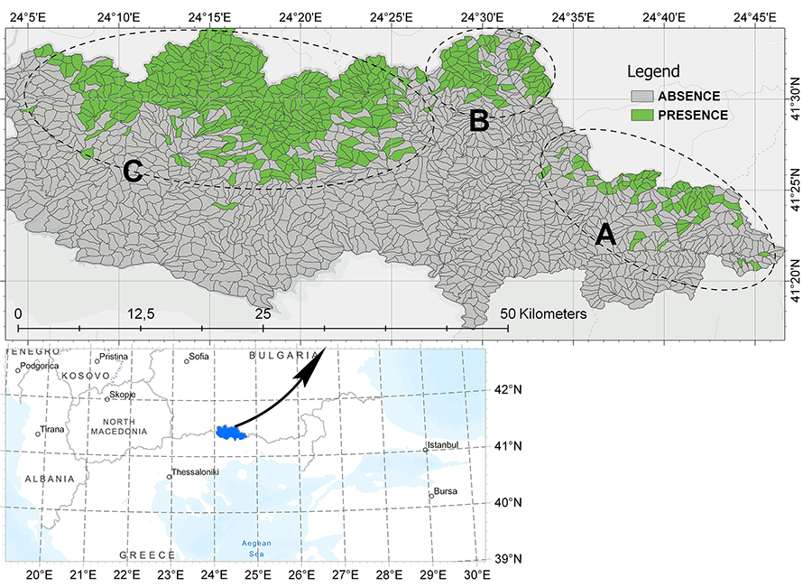
Because species presence is recorded at the polygon level, the centroid of each polygon can serve as the spatial reference for presence-data. This approach, however, introduces some spatial uncertainty in the location of presence data (species absence can be safely assumed throughout the absence-polygon area). To quantify positional uncertainty, we computed three geometric descriptors for each spruce-presence polygon: the minimum, average, and maximum Euclidean distances from the centroid to the polygon edges using the ”sf” package of R (Pebesma, 2018; Table 1). The corresponding median values across 500 polygons were 197 m, 460 m, and 764 m, respectively. These distances represent maximum potential positional errors, assuming the species could be located anywhere within the polygon, including near its boundaries.

Author contributions

Kalliopi Giannakoglou: Writing - original draft, Data curation, Formal analysis, Investigation. Georgios Michailidis, Aleksandros Tsiridis, Ioannis Aptoglou, Michail Karatzoglou: Data collection. Alexandros Galanidis, Vasileios Giannakopoulos: Data curation, Validation, Methodology. Nikos Nanos: Conceptualization, Methodology, Supervision, Writing – Review & Editing.

Data and code availability

The Norway spruce data is available in Zenodo, https://doi.org/10.5281/zenodo.10959759 and in GBIF, https://cloud.gbif.org/eca/resource?r=picea-abies-rhodopes.

Funding, Required Permits, Potential Conflicts of Interest, and Acknowledgments

This project was funded by the General Secretariat of Forests, Greek Ministry of Environment and Energy, as part of a broader initiative on forest management of public forests.

References

Alberto, F., Aitken, S., Alía, R., González-Martínez, S., Hänninen, H., Kremer, A., … Savolainen, O. (2013). Potential for evolutionary responses to climate change – evidence from tree populations. Global Change Biology, 19(6), 1645–1661. https://doi.org/10.1111/gcb.12181

Ambs, D., Schmied, G., Zlatanov, T., Kienlein, S., Pretzsch, H. & Nikolova, P.S. (2024). Regeneration dynamics in mixed mountain forests at their natural geographical distribution range in the Western Rhodopes. Forest Ecology and Management, 552, 121550. https://doi.org/10.1016/j.foreco.2023.121550

Bonannella, C., Hengl, T., Heisig, J., Parente, L., Wright, M., Herold, M. & Bruin, S.D. (2022). Forest tree species distribution for Europe 2000–2020: mapping potential and realized distributions using spatiotemporal machine learning. PeerJ, 10, e13728. https://doi.org/10.7717/peerj.13728

Booth, T. (2018). Species distribution modelling tools and databases to assist managing forests under climate change. Forest Ecology and Management, 430, 196–203. https://doi.org/10.1016/j.foreco.2018.08.019

Caudullo, G., Welk, E. & San-Miguel-Ayanz, J. (2017). Chorological maps for the main European woody species. Data in Brief, 12, 662–666. https://doi.org/10.1016/j.dib.2017.05.007

Erichsen, E.O., Budde, K.B., Sagheb-Talebi, K., Bagnoli, F., Vendramin, G.G. & Hansen, O.K. (2018). Hyrcanian forests—Stable rear-edge populations harbouring high genetic diversity of Fraxinus excelsior, a common European tree species. Diversity and Distributions, 24(11), 1521–1533. https://doi.org/10.1111/ddi.12783

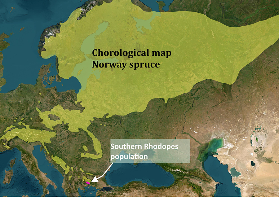
EUFORGEN (2009). Distribution map of Norway spruce (Picea abies). Exported from: https://www.euforgen.org/species/picea-abies/ on October 22, 2025.

GDAL/OGR contributors (2025). GDAL/OGR Geospatial Data Abstraction software Library. Open Source Geospatial Foundation. [used on January 20, 2025]. Available at: https://doi.org/10.5281/zenodo.5884351

Grigoriadis, N., Petermann, J., Schröder, E. & Spyroglou, G. (2012). Contribution to the assessment of the conservation status of spruce forests in Greece. Journal of Biological Research-Thessaloniki, 17, 57‑67. Available at: https://www.proquest.com/scholarly-journals/contribution-assessment-conservation-status/docview/1017699082/se-2

Heberling, J.M., Miller, J., Noesgaard, D., Weingart, S. & Schigel, D. (2021). Data integration enables global biodiversity synthesis. Proceedings of the National Academy of Sciences, 118(6), e2018093118. https://doi.org/10.1073/pnas.2018093118

Hellenic Cadastre (2020). LSO25 orthophotos, Greece. Exported on 10 November 2024 from: https://www.ktimanet.gr/geoportal/catalog/search/resource/details.page?uuid=%7B6803818C-284B-442F-8185-707FDB654A22%7D

Hellenic Cadastre (2023). Certified Forest Maps, Greece. Exported on 10 November 2024 from: https://www.ktimanet.gr/geoportal/catalog/search/resource/details.page?uuid=%7B43B75001-F20E-44F9-84FE-BBADC23BD9DB%7D

Heubel, S., Rammig, A. & Buras, A. (2025). The forest after tomorrow: Projecting the impact of a collapsing Atlantic meridional overturning circulation on European treespecies Distributions. Global Change Biology, 31(4), e70185. https://doi.org/10.1111/gcb.70185

Hilmers, T., Biber, P., Knoke, T. & Pretzsch, H. (2020). Assessing transformation scenarios from pure Norway spruce to mixed uneven-aged forests in mountain areas. European Journal of Forest Research, 139(4), 567–584. https://doi.org/10.1007/s10342-020-01270-y

ISO 19157:2023. (2023). Geographic information — Data quality. International Organization for Standardization.

Martes, L., Pfleiderer, P., Köhl, M. & Sillmann, J. (2024). Using climate envelopes and earth system model simulations for assessing climate change induced forest vulnerability. Scientific Reports, 14(1), 17076. https://doi.org/10.1038/s41598-024-68181-5

Mauri, A., Strona, G. & San-Miguel-Ayanz, J. (2017). EU-Forest, a high-resolution tree occurrence dataset for Europe. Scientific Data, 4(1), 160123.  https://doi.org/10.1038/sdata.2016.123

Mauri, A., Girardello, M., Strona, G., Beck, P.A., Forzieri, G., Caudullo, G., … Cescatti, A. (2022). EU-Trees4F, a dataset on the future distribution of European tree species. Scientific Data, 9(1), 37. https://doi.org/10.1038/s41597-022-01128-5

Michailidis, G., Giannakoglou, K., Tsiridis, A., Aptoglou, I. & Karatzoglou, M. (2025). Presence/absence of Norway spruce (Picea abies (L.) Karst.) in Southern Rhodopes/Greece (Version 2) [Data set]. Zenodo. Exported from https://doi.org/10.5281/zenodo.10959758 on 22 June 2025.

Michailidis, G., Giannakoglou, K., Tsiridis, A., Aptoglou, I. & Karatzoglou, M. (2026). Presence/absence of Norway spruce (Picea abies (L.) Karst.) in Southern Rhodopes, Greece (1970-2019). Occurrence dataset. https://doi.org/10.5281/zenodo.17571125. Available at: https://cloud.gbif.org/eca/resource?r=picea-abies-rhodopes

Mugnier, C.J. (2021). Grids & datums: THE HELLENIC REPUBLIC. Photogrammetric Engineering and Remote Sensing, 87(1), 13–14. https://doi.org/10.14358/PERS.87.1.13

Oikonomakis, N. & Ganatsas, P. (2012). Land cover changes and forest succession trends in a site of Natura 2000 network (Elatia forest), in northern Greece. Forest Ecology and Management, 285, 153‑163. https://doi.org/10.1016/j.foreco.2012.08.013

Papadopoulou, D., Raptis, D., Kazana, V. & Tsitsoni, T. (2023). Exploring texture diversity of beech-spruce-fir stands through development phase analysis in the Frakto Virgin Forest of Greece. Diversity, 15(2), 278. https://doi.org/10.3390/d15020278

Pebesma, E. (2018). Simple Features for R: Standardized support for spatial vector data. The R Journal, 10(1), 439–446. doi:10.32614/RJ-2018-009.

QGIS Development Team (2025). QGIS Geographic Information System. Open Source Geospatial Foundation. [used on June 20, 2025]. Available at: http://qgis.org

Ravazzi, C. (2002). Late Quaternary history of spruce in southern Europe. Review of Palaeobotany and Palynology, 120(1-2), 131–177. https://doi.org/10.1016/S0034-6667(01)00149-X

Schlyter, P., Stjernquist, I., Bärring, L., Jönsson, A.M. & Nilsson, C. (2006). Assessment of the impacts of climate change and weather extremes on boreal forests in northern Europe, focusing on Norway spruce. Climate Research, 31(1), 75–84. https://doi.org/10.3354/cr031075

Vilà-Cabrera, A., Premoli, A. & Jump, A. (2019). Refining predictions of population decline at species' rear edges. Global Change Biology, 25(5), 1549–1560. https://doi.org/10.1111/gcb.14597

Warmerdam, F. (2008). The Geospatial Data Abstraction Library. In: Hall, G.B., Leahy, M.G. (eds) Open Source Approaches in Spatial Data Handling. Springer, Berlin, Heidelberg. https://doi.org/10.1007/978-3-540-74831-1_5

Xofis, P., Spiliotis, J., Chatzigiovanakis, S. & Chrysomalidou, A. (2022). Long-term monitoring of vegetation dynamics in the Rhodopi Mountain Range National Park-Greece. Forests, 13(3), 377. https://doi.org/10.3390/f13030377

Zlatanov, T., Elkin, C., Irauschek, F. & Lexer, M.J. (2017). Impact of climate change on vulnerability of forests and ecosystem service supply in Western Rhodopes Mountains. Regional Environmental Change, 17(1), 79–91. https://doi.org/10.1007/s10113-015-0869-z

Zurell, D., Franklin, J., König, C., Bouchet, P., Dormann, C., Elith, J., … Merow, C. (2020). A standard protocol for reporting species distribution models. Ecography, 43(9), 1261– 1277. https://doi.org/10.1111/ecog.04960